
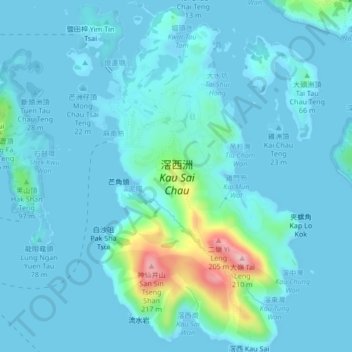
滘西洲 Kau Sai Chau topographic map
Interactive map
Click on the map to display elevation.
About this map
Name: 滘西洲 Kau Sai Chau topographic map, elevation, terrain.
Average elevation: 69 ft
Minimum elevation: -7 ft
Maximum elevation: 614 ft
Other topographic maps
Click on a map to view its topography, its elevation and its terrain.
蓮花山 Lin Fa Shan
Chine > Hong Kong > 離島區 Islands District
蓮花山 Lin Fa Shan, 離島區 Islands District, Nouveaux Territoires, Hong Kong, Chine
Average elevation: 1,322 ft
孔嶺 Hung Leng
Chine > Hong Kong > 北區 North District > 軍地村 Kwan Tei Tsuen
孔嶺 Hung Leng, 軍地村 Kwan Tei Tsuen, 北區 North District, Nouveaux Territoires, Hong Kong, Chine
Average elevation: 180 ft
中區 Central District
Chine > Hong Kong > Île de Hong Kong
中區 Central District, Île de Hong Kong, Hong Kong, Chine
Average elevation: 374 ft
獺灣 Chat Wan
Chine > Hong Kong > 西貢區 Sai Kung District
獺灣 Chat Wan, 西貢區 Sai Kung District, Nouveaux Territoires, Hong Kong, Chine
Average elevation: 56 ft
鳳園 Fung Yuen
Chine > Hong Kong > 大埔區 Tai Po District > 鳳園 Fung Yuen
鳳園 Fung Yuen, 大埔區 Tai Po District, Nouveaux Territoires, Hong Kong, Chine
Average elevation: 262 ft
北區 North District
北區 North District, Nouveaux Territoires, Hong Kong, Chine
Average elevation: 377 ft
九肚 Kau To
Chine > Hong Kong > 九肚 Kau To > 沙田 Sha Tin
九肚 Kau To, 沙田 Sha Tin, 沙田區 Sha Tin District, Nouveaux Territoires, Hong Kong, Chine
Average elevation: 361 ft
Nouveaux Territoires
Nouveaux Territoires, Hong Kong, Chine
Average elevation: 144 ft