Geolocate

Northampton topographic map

Interactive map

Click on the map to display elevation.

About this map

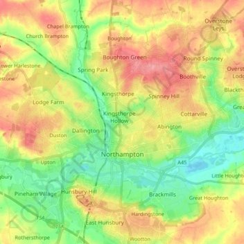
Name: Northampton topographic map, elevation, terrain.

Location: Northampton, West Northamptonshire, England, United Kingdom (52.21939 -0.95505 52.28270 -0.79137)

Average elevation: 292 ft

Minimum elevation: 161 ft

Maximum elevation: 443 ft

As with the rest of the British Isles, Northampton experiences an oceanic climate with cool summers and mild winters. The official Met Office weather station for Northampton is the Moulton Park Weather Station at the University of Northampton. Situated at an elevation of around 130 m (427 ft) above sea level compared to Northampton town centre at 50 to 60 m (164 to 197 ft), it is one of the highest points in the town, and so may not be a perfect representation of Northampton as a whole. Its hilltop location means less pooling of cold air on calm clear nights, and lower maxima during summer. The absolute maximum recorded is 34.7 °C (94.5 °F) on 3 August 1990. A high of 34.4 °C (93.9 °F) was recorded on 19 July 2006, However, a maximum temperature of 40.2 °C (104.4 °F) was recorded on 19 July 2022 at Pitsford, located 4.4 miles (7.1 km) from the town centre. The absolute minimum is −16.8 °C (1.8 °F), recorded during February 1986. It is likely the absolute maximum in the town centre is a degree or so higher owing to the lower elevation, and absolute minimum on the eastern and western edges of the urban area around the Nene valley a couple of degrees colder due to katabatic drainage of cold air allowing a frost hollow effect. Most recently, the temperature fell to −9.6 °C (14.7 °F) on 20 December 2010.

Wikipedia (CC-BY-SA 3.0)

Other topographic maps

Click on a map to view its topography, its elevation and its terrain.

Northampton

United Kingdom > England > West Northamptonshire > Northampton

Northampton, West Northamptonshire, England, United Kingdom

Average elevation: 292 ft

Cold Higham

United Kingdom > England > West Northamptonshire

Cold Higham, West Northamptonshire, England, United Kingdom

Average elevation: 430 ft

Long Buckby Wharf

United Kingdom > England > West Northamptonshire

Long Buckby Wharf, Long Buckby, West Northamptonshire, England, NN6 7PP, United Kingdom

Average elevation: 374 ft

Fosters Booth

United Kingdom > England > West Northamptonshire

Fosters Booth, Pattishall, West Northamptonshire, England, NN12 8LB, United Kingdom

Average elevation: 420 ft

Yardley Hastings

United Kingdom > England > West Northamptonshire

Yardley Hastings, West Northamptonshire, England, United Kingdom

Average elevation: 308 ft

Spratton

United Kingdom > England > West Northamptonshire

Spratton, West Northamptonshire, England, United Kingdom

Average elevation: 322 ft

Litchborough

United Kingdom > England > West Northamptonshire

Litchborough, West Northamptonshire, England, United Kingdom

Average elevation: 466 ft

Upton Country Park

United Kingdom > England > West Northamptonshire > Harpole

Upton Country Park, Upton, Harpole, West Northamptonshire, England, United Kingdom

Average elevation: 246 ft

Castle Ashby

United Kingdom > England > West Northamptonshire

Castle Ashby, West Northamptonshire, England, NN7 1LF, United Kingdom

Average elevation: 233 ft

Lower Thorpe

United Kingdom > England > West Northamptonshire > Thorpe Mandeville

Lower Thorpe, Thorpe Mandeville, West Northamptonshire, England, OX17 2HP, United Kingdom

Average elevation: 505 ft

Maidford

United Kingdom > England > West Northamptonshire

Maidford, West Northamptonshire, England, United Kingdom

Average elevation: 515 ft

Onley

United Kingdom > England > West Northamptonshire

Onley, West Northamptonshire, England, CV23 8AW, United Kingdom

Average elevation: 325 ft

Stoke Bruerne

United Kingdom > England > West Northamptonshire

Stoke Bruerne, West Northamptonshire, England, NN12 7SD, United Kingdom

Average elevation: 322 ft

Pitsford Water

United Kingdom > England > West Northamptonshire > Pitsford

Pitsford Water, Pitsford, West Northamptonshire, England, United Kingdom

Average elevation: 354 ft

Nether Heyford

United Kingdom > England > West Northamptonshire

Nether Heyford, West Northamptonshire, England, United Kingdom

Average elevation: 299 ft

Great Brington

United Kingdom > England > West Northamptonshire

Great Brington, West Northamptonshire, England, NN7 4JD, United Kingdom

Average elevation: 387 ft

Foxley

United Kingdom > England > West Northamptonshire > Blakesley

Foxley, Blakesley, West Northamptonshire, England, NN12 8HP, United Kingdom

Average elevation: 456 ft

Sibbertoft

United Kingdom > England > West Northamptonshire > Sibbertoft

Sibbertoft, West Northamptonshire, England, United Kingdom

Average elevation: 512 ft

Thenford

United Kingdom > England > West Northamptonshire

Thenford, West Northamptonshire, England, United Kingdom

Average elevation: 440 ft

Braunston

United Kingdom > England > West Northamptonshire > Braunston

Braunston, West Northamptonshire, England, United Kingdom

Average elevation: 420 ft

Blakesley

United Kingdom > England > West Northamptonshire

Blakesley, West Northamptonshire, England, United Kingdom

Average elevation: 463 ft

Creaton

United Kingdom > England > West Northamptonshire > Great Creaton

Creaton, Great Creaton, West Northamptonshire, England, United Kingdom

Average elevation: 348 ft

Watford Gap

United Kingdom > England > West Northamptonshire

Watford Gap, Watford, West Northamptonshire, England, NN6 7UH, United Kingdom

Average elevation: 456 ft

Draughton

United Kingdom > England > West Northamptonshire

Draughton, West Northamptonshire, England, United Kingdom

Average elevation: 459 ft

Silverstone

United Kingdom > England > West Northamptonshire

Silverstone, West Northamptonshire, England, United Kingdom

Average elevation: 436 ft

Tiffield

United Kingdom > England > West Northamptonshire

Tiffield, West Northamptonshire, England, NN12 8AB, United Kingdom

Average elevation: 400 ft

Brockhall

United Kingdom > England > West Northamptonshire

Brockhall, West Northamptonshire, England, United Kingdom

Average elevation: 344 ft

Kelmarsh

United Kingdom > England > West Northamptonshire

Kelmarsh, West Northamptonshire, England, United Kingdom

Average elevation: 453 ft

Hunsbury Hill

United Kingdom > England > West Northamptonshire > Far Cotton

Hunsbury Hill, Far Cotton, West Northamptonshire, England, NN4 9RR, United Kingdom

Average elevation: 259 ft

Harlestone

United Kingdom > England > West Northamptonshire

Harlestone, West Northamptonshire, England, United Kingdom

Average elevation: 335 ft

Croughton

United Kingdom > England > West Northamptonshire

Croughton, West Northamptonshire, England, United Kingdom

Average elevation: 417 ft

Barby

United Kingdom > England > West Northamptonshire

Barby, West Northamptonshire, England, United Kingdom

Average elevation: 374 ft

Old Mill Race

United Kingdom > England > West Northamptonshire > Whilton

Old Mill Race, Norton, Whilton, West Northamptonshire, England, NN7 4JZ, United Kingdom

Average elevation: 358 ft

Pattishall

United Kingdom > England > West Northamptonshire

Pattishall, West Northamptonshire, England, United Kingdom

Average elevation: 410 ft

Ladybridge Park

United Kingdom > England > West Northamptonshire

Ladybridge Park, West Hunsbury, West Northamptonshire, England, United Kingdom

Average elevation: 266 ft

Bradden

United Kingdom > England > West Northamptonshire

Bradden, West Northamptonshire, England, United Kingdom

Average elevation: 387 ft

Whitfield

United Kingdom > England > West Northamptonshire

Whitfield, West Northamptonshire, England, United Kingdom

Average elevation: 420 ft

Duston

United Kingdom > England > West Northamptonshire > Duston

Duston, West Northamptonshire, England, United Kingdom

Average elevation: 318 ft

Puxley

United Kingdom > England > West Northamptonshire

Puxley, Deanshanger, West Northamptonshire, England, NN12 7QS, United Kingdom

Average elevation: 312 ft

Sulgrave

United Kingdom > England > West Northamptonshire

Sulgrave, West Northamptonshire, England, United Kingdom

Average elevation: 515 ft

Honey Hill

United Kingdom > England > West Northamptonshire

Honey Hill, West Northamptonshire, England, NN6 6NL, United Kingdom

Average elevation: 554 ft

Edgcote

United Kingdom > England > West Northamptonshire > Chipping Warden

Edgcote, Chipping Warden and Edgcote, Chipping Warden, West Northamptonshire, England, OX17 1AG, United Kingdom

Average elevation: 436 ft

Preston Capes

United Kingdom > England > West Northamptonshire

Preston Capes, West Northamptonshire, England, United Kingdom

Average elevation: 512 ft

Middleton Cheney

United Kingdom > England > West Northamptonshire

Middleton Cheney, West Northamptonshire, England, United Kingdom

Average elevation: 420 ft

Moreton Pinkney

United Kingdom > England > West Northamptonshire

Moreton Pinkney, West Northamptonshire, England, United Kingdom

Average elevation: 495 ft

Overstone

United Kingdom > England > West Northamptonshire

Overstone, West Northamptonshire, England, United Kingdom

Average elevation: 358 ft

Upper Stowe

United Kingdom > England > West Northamptonshire > Upper Stowe

Upper Stowe, West Northamptonshire, England, NN7 4SL, United Kingdom

Average elevation: 377 ft

Kingsthorpe

United Kingdom > England > West Northamptonshire

Kingsthorpe, West Northamptonshire, England, United Kingdom

Average elevation: 312 ft

East Hunsbury

United Kingdom > England > West Northamptonshire

East Hunsbury, West Northamptonshire, England, United Kingdom

Average elevation: 285 ft

Hellidon

United Kingdom > England > West Northamptonshire

Hellidon, West Northamptonshire, England, United Kingdom

Average elevation: 522 ft