
Make a donation
Gear up for your next adventure:
As an Amazon Associate, this site earns from qualifying purchases at no extra cost to you.
Banning State Park topographic map
Click on the map to display elevation.
Make a donation
Gear up for your next adventure:
As an Amazon Associate, this site earns from qualifying purchases at no extra cost to you.
Banning State Park
Below the rapids, the valley once again begins to widen. Away from the river valley, the topography is generally level to gently-rolling glacial till plain.
Make a donation
Gear up for your next adventure:
As an Amazon Associate, this site earns from qualifying purchases at no extra cost to you.
About this map
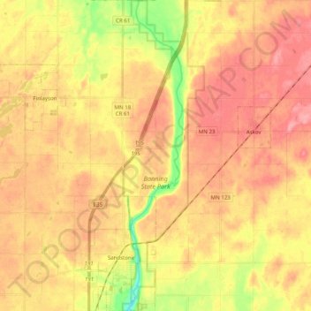
Name: Banning State Park topographic map, elevation, terrain.
Location: Banning State Park, Pine County, Minnesota, United States (46.10722 -92.86651 46.24486 -92.81407)
Average elevation: 1,109 ft
Minimum elevation: 935 ft
Maximum elevation: 1,217 ft
Pine County trails, hiking, mountain biking, running and outdoor activities
Make a donation
Gear up for your next adventure:
As an Amazon Associate, this site earns from qualifying purchases at no extra cost to you.
Other topographic maps
Click on a map to view its topography, its elevation and its terrain.
Devils Lake
United States > Minnesota > Pine County > Pine City > Pine Terrace Mobile Home Park
Average elevation: 968 ft
Chengwatana State Forest
United States > Minnesota > Pine County > Rock Creek
Average elevation: 925 ft
Make a donation
Gear up for your next adventure:
As an Amazon Associate, this site earns from qualifying purchases at no extra cost to you.