
Make a donation
Gear up for your next adventure:
As an Amazon Associate, this site earns from qualifying purchases at no extra cost to you.
Beroun topographic map
Click on the map to display elevation.
Make a donation
Gear up for your next adventure:
As an Amazon Associate, this site earns from qualifying purchases at no extra cost to you.
About this map
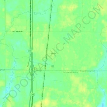
Name: Beroun topographic map, elevation, terrain.
Location: Beroun, Pine County, Minnesota, United States (45.89023 -92.97521 45.93023 -92.93521)
Average elevation: 971 ft
Minimum elevation: 938 ft
Maximum elevation: 994 ft
Pine County trails, hiking, mountain biking, running and outdoor activities
Make a donation
Gear up for your next adventure:
As an Amazon Associate, this site earns from qualifying purchases at no extra cost to you.
Other topographic maps
Click on a map to view its topography, its elevation and its terrain.
Devils Lake
United States > Minnesota > Pine County > Pine City > Pine Terrace Mobile Home Park
Average elevation: 968 ft
Make a donation
Gear up for your next adventure:
As an Amazon Associate, this site earns from qualifying purchases at no extra cost to you.
Chengwatana State Forest
United States > Minnesota > Pine County > Rock Creek
Average elevation: 925 ft
Make a donation
Gear up for your next adventure:
As an Amazon Associate, this site earns from qualifying purchases at no extra cost to you.
Banning State Park
United States > Minnesota > Pine County
Below the rapids, the valley once again begins to widen. Away from the river valley, the topography is generally level to gently-rolling glacial till plain.
Average elevation: 1,109 ft