Geolocate

Boquerón topographic map

Click on the map to display elevation.

About this map

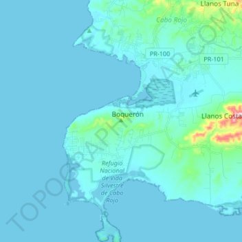
Name: Boquerón topographic map, elevation, terrain.

Location: Boquerón, Cabo Rojo, Puerto Rico, United States (17.93245 -67.21535 18.05964 -67.13918)

Average elevation: 62 ft

Minimum elevation: 0 ft

Maximum elevation: 873 ft

Puerto Rico trails, hiking, mountain biking, running and outdoor activities

Other topographic maps

Click on a map to view its topography, its elevation and its terrain.

Cerro Mariquita

United States > Puerto Rico > Cabo Rojo

Average elevation: 397 ft

Cabo Rojo

United States > Puerto Rico > Cabo Rojo

Average elevation: 148 ft

Gear up for your next adventure:

🎒Trail Energy Bars - High‑calorie bars for hiking energy
🛏️Cold Weather Sleeping Bag - Warm sleeping bag for cold conditions
🧦Hiking Socks - Comfortable socks to prevent blisters on long hikes
🔋Solar Power Banks - Keep your GPS and phone charged in remote wilderness areas
🔊Portable Camp Speaker - Music and alerts at camp

As an Amazon Associate, this site earns from qualifying purchases at no extra cost to you.