Geolocate

Cabo Rojo topographic map

Click on the map to display elevation.

About this map

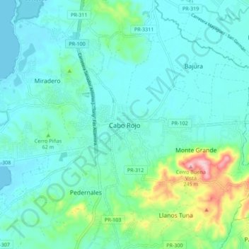
Name: Cabo Rojo topographic map, elevation, terrain.

Location: Cabo Rojo, Puerto Rico, 00623-0910, United States (18.04702 -67.18591 18.12702 -67.10591)

Average elevation: 148 ft

Minimum elevation: 0 ft

Maximum elevation: 810 ft

Puerto Rico trails, hiking, mountain biking, running and outdoor activities

Other topographic maps

Click on a map to view its topography, its elevation and its terrain.

Guanajibo

United States > Puerto Rico > Cabo Rojo

Average elevation: 62 ft

Boquerón

United States > Puerto Rico > Cabo Rojo

Average elevation: 62 ft

Gear up for your next adventure:

🪵Folding Camp Saw - Compact saw for wood and campsite work
🔭Stargazing Telescopes - Perfect for camping in low-light pollution areas shown on maps
🌧️Backpack Rain Cover - Keep gear dry in wet weather
🧯Portable Fire Pit - Compact fire pit for camping spots
🕶️Glacier Sunglasses - Side shields to protect eyes from high-altitude snow glare

As an Amazon Associate, this site earns from qualifying purchases at no extra cost to you.