
Curdworth topographic map
Click on the map to display elevation.
About this map
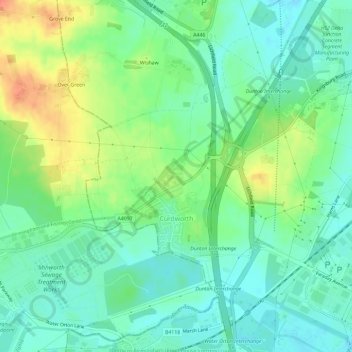
Name: Curdworth topographic map, elevation, terrain.
Average elevation: 285 ft
Minimum elevation: 230 ft
Maximum elevation: 387 ft
Other topographic maps
Click on a map to view its topography, its elevation and its terrain.
Brook End
United Kingdom > England > Warwickshire > North Warwickshire > Hurley
Average elevation: 351 ft
Gilson
United Kingdom > England > Warwickshire > North Warwickshire > Coleshill CP
Average elevation: 269 ft
Pooley Country Park
United Kingdom > England > Warwickshire > North Warwickshire > Polesworth
Average elevation: 249 ft
Baddesley Ensor
United Kingdom > England > Warwickshire > North Warwickshire
Average elevation: 364 ft
Hartshill Hayes Country Park
United Kingdom > England > Warwickshire > North Warwickshire > Ansley Common
Average elevation: 417 ft
Curdworth Locks
United Kingdom > England > Warwickshire > North Warwickshire > Kingsbury > Curdworth CP
Average elevation: 262 ft
Merevale Lake
United Kingdom > England > Warwickshire > North Warwickshire > Atherstone
Average elevation: 390 ft
Church End
United Kingdom > England > Warwickshire > North Warwickshire > Ansley CP
Average elevation: 495 ft
Nether Whitacre
United Kingdom > England > Warwickshire > North Warwickshire
Average elevation: 272 ft
Holbech's Wood
United Kingdom > England > Warwickshire > North Warwickshire > Fillongley CP
Average elevation: 459 ft
Hoar Park
United Kingdom > England > Warwickshire > North Warwickshire > Bentley CP
Average elevation: 443 ft
Hunts Green
United Kingdom > England > Warwickshire > North Warwickshire > Middleton CP
Average elevation: 266 ft
Lea Marston Purification Lakes
United Kingdom > England > Warwickshire > North Warwickshire > Marston
Average elevation: 230 ft