
Nether Whitacre topographic map
Click on the map to display elevation.
About this map
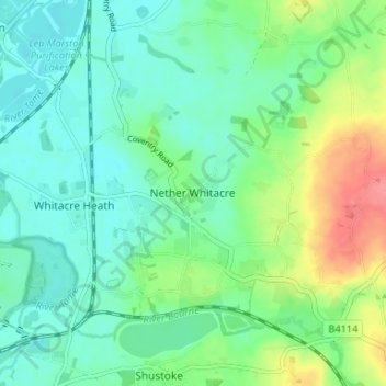
Name: Nether Whitacre topographic map, elevation, terrain.
Average elevation: 272 ft
Minimum elevation: 203 ft
Maximum elevation: 443 ft
Other topographic maps
Click on a map to view its topography, its elevation and its terrain.
Newton Regis CP
United Kingdom > England > Warwickshire > North Warwickshire
Average elevation: 279 ft
Pooley Country Park
United Kingdom > England > Warwickshire > North Warwickshire > Polesworth
Average elevation: 249 ft
Hartshill Hayes Country Park
United Kingdom > England > Warwickshire > North Warwickshire > Ansley Common
Average elevation: 417 ft
Merevale Lake
United Kingdom > England > Warwickshire > North Warwickshire > Atherstone
Average elevation: 390 ft
Holbech's Wood
United Kingdom > England > Warwickshire > North Warwickshire > Fillongley CP
Average elevation: 459 ft
Hoar Park
United Kingdom > England > Warwickshire > North Warwickshire > Bentley CP
Average elevation: 443 ft
Lea Marston Purification Lakes
United Kingdom > England > Warwickshire > North Warwickshire > Marston
Average elevation: 230 ft