Geolocate

Royder topographic map

Click on the map to display elevation.

About this map

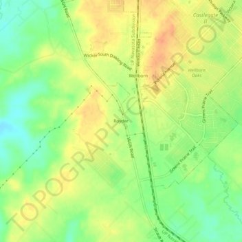
Name: Royder topographic map, elevation, terrain.

Location: Royder, Brazos County, Texas, 77881, United States (30.50770 -96.32496 30.54770 -96.28496)

Average elevation: 308 ft

Minimum elevation: 236 ft

Maximum elevation: 367 ft

Brazos County trails, hiking, mountain biking, running and outdoor activities

Other topographic maps

Click on a map to view its topography, its elevation and its terrain.

College Station

United States > Texas > Brazos County

Average elevation: 285 ft

College Station

United States > Texas > Brazos County

Average elevation: 285 ft

Bryan

United States > Texas > Brazos County

Average elevation: 302 ft

Bryan

United States > Texas > Brazos County

Average elevation: 302 ft

Bryan

United States > Texas > Brazos County

Average elevation: 302 ft

Bryan

United States > Texas > Brazos County

Average elevation: 302 ft

College Station

United States > Texas > Brazos County

Average elevation: 285 ft

Gear up for your next adventure:

🔭Stargazing Telescopes - Perfect for camping in low-light pollution areas shown on maps
🪶Compact Camp Shovel - Folding shovel for campsite tasks
🎁Geography Themed Gifts - Unique gift ideas for map lovers and geography enthusiasts
🪶Wildlife Field Guides - Learn animal tracking and species ID
🧯Portable Fire Pit - Compact fire pit for camping spots

As an Amazon Associate, this site earns from qualifying purchases at no extra cost to you.