Geolocate

College Station topographic map

Click on the map to display elevation.

About this map

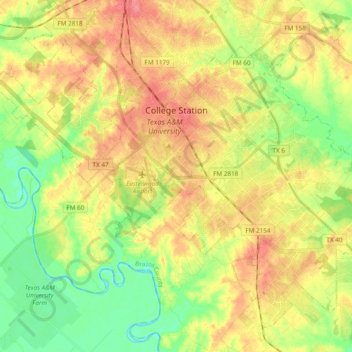
Name: College Station topographic map, elevation, terrain.

Location: College Station, Brazos County, Texas, United States (30.51648 -96.38765 30.65841 -96.19656)

Average elevation: 285 ft

Minimum elevation: 180 ft

Maximum elevation: 390 ft

Brazos County trails, hiking, mountain biking, running and outdoor activities

Other topographic maps

Click on a map to view its topography, its elevation and its terrain.

Royder

United States > Texas > Brazos County

Average elevation: 308 ft

Rye

United States > Texas > Brazos County

Average elevation: 285 ft

Union

United States > Texas > Brazos County

Average elevation: 318 ft

Wicker

United States > Texas > Brazos County > College Station

Average elevation: 308 ft

Gear up for your next adventure:

🧥Men's Rain Shells - Premium waterproof and breathable jackets for mountain weather
🧭Outdoor Navigation Book - Learn advanced navigation skills
🧺Microfiber Travel Towels - Compact and fast-drying towels for trail use
🥇GPS Hiking Watch - Multi‑sport GPS watch with navigation and trail tracking
🧦Hiking Socks - Comfortable socks to prevent blisters on long hikes

As an Amazon Associate, this site earns from qualifying purchases at no extra cost to you.