Geolocate

Santa Rosa de Cabal topographic map

Click on the map to display elevation.

About this map

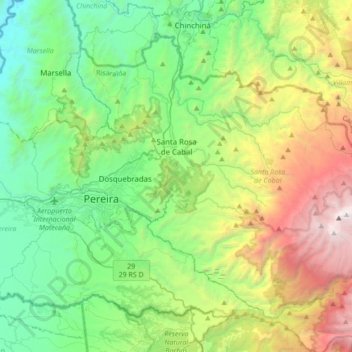
Name: Santa Rosa de Cabal topographic map, elevation, terrain.

Location: Santa Rosa de Cabal, Risaralda, RAP Eje Cafetero, 661020, Colombia (4.69793 -75.71849 4.97518 -75.37549)

Average elevation: 6,411 ft

Minimum elevation: 2,759 ft

Maximum elevation: 15,013 ft

Other topographic maps

Click on a map to view its topography, its elevation and its terrain.

Beltran

Colombia > Risaralda > Marsella

Average elevation: 3,537 ft

Alto Cerritos

Colombia > Risaralda

Average elevation: 3,835 ft

Pereira

Colombia > Risaralda > Pereira > Pereira

Average elevation: 5,131 ft

Apía

Colombia > Risaralda > Apía > Apía

Apía is a town and municipality in the Department of Risaralda, Colombia. It is located at an elevation of 1,630 metres, about 60 km away from district capital Pereira in the valley of the Apia river. It has approximately 11,000 inhabitants according to the 2018 census. The town has excellent views over the…

Average elevation: 5,400 ft

Gear up for your next adventure:

🌡️Portable Weather Meter - Track weather conditions on the trail
🔭Stargazing Telescopes - Perfect for camping in low-light pollution areas shown on maps
🏫Relief Map Kits - Hands-on tools for teaching landforms and elevation
🦶Carbon Trekking Poles - Reduce knee impact on steep descents with ultra-light poles
🛰️Handheld GPS Units - Professional satellite navigators for precise backcountry mapping

As an Amazon Associate, this site earns from qualifying purchases at no extra cost to you.