Geolocate

Black Hawk topographic map

Click on the map to display elevation.

About this map

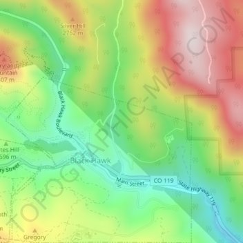
Name: Black Hawk topographic map, elevation, terrain.

Location: Black Hawk, Gilpin County, Colorado, United States (39.79192 -105.50565 39.81046 -105.47855)

Average elevation: 8,550 ft

Minimum elevation: 7,904 ft

Maximum elevation: 9,567 ft

Gilpin County trails, hiking, mountain biking, running and outdoor activities

Other topographic maps

Click on a map to view its topography, its elevation and its terrain.

Rogers Pass

United States > Colorado > Gilpin County

Rogers Pass, elevation 11,866 ft (3,617 m), is a mountain pass in the Front Range of central Colorado. The pass crosses the continental divide in the James Peak Wilderness.

Average elevation: 11,312 ft

Blackhawk Peak

United States > Colorado > Gilpin County

Average elevation: 9,551 ft

Tolland

United States > Colorado > Gilpin County

Average elevation: 9,442 ft

Starr Peak

United States > Colorado > Gilpin County

Average elevation: 9,610 ft

Tolland

United States > Colorado > Gilpin County > Tolland

Average elevation: 9,442 ft

Blackhawk Peak

United States > Colorado > Gilpin County

Average elevation: 9,551 ft

Rollinsville

United States > Colorado > Gilpin County > Rollinsville

Average elevation: 8,681 ft

Gear up for your next adventure:

🧭Outdoor Navigation Book - Learn advanced navigation skills
🎒Trail Energy Bars - High‑calorie bars for hiking energy
🪓Survival Multi‑Tool - Versatile tool for camp and trail tasks
🏫Relief Map Kits - Hands-on tools for teaching landforms and elevation
🩹Survival Bandages - High‑quality bandages for emergencies

As an Amazon Associate, this site earns from qualifying purchases at no extra cost to you.