Geolocate

Pinola topographic map

Click on the map to display elevation.

About this map

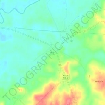
Name: Pinola topographic map, elevation, terrain.

Location: Pinola, Simpson County, Mississippi, United States (31.85710 -89.98203 31.89710 -89.94203)

Average elevation: 315 ft

Minimum elevation: 236 ft

Maximum elevation: 469 ft

Simpson County trails, hiking, mountain biking, running and outdoor activities

Other topographic maps

Click on a map to view its topography, its elevation and its terrain.

Mendenhall

United States > Mississippi > Simpson County

Average elevation: 358 ft

Magee

United States > Mississippi > Simpson County

Average elevation: 433 ft

Gear up for your next adventure:

Solar GPS Watches - Advanced multisport watches with built-in topographic maps
🧺Microfiber Travel Towels - Compact and fast-drying towels for trail use
🔦Powerful Headlamps - Ultra-bright hands-free lighting for night navigation
🪶Camping Sleeping Pad - Comfortable sleeping pad for backpacking
🏕️Tent Footprint - Protect your tent base from wear

As an Amazon Associate, this site earns from qualifying purchases at no extra cost to you.