
Make a donation
Gear up for your next adventure:
As an Amazon Associate, this site earns from qualifying purchases at no extra cost to you.
Lateis / Latais topographic map
Click on the map to display elevation.
Make a donation
Gear up for your next adventure:
As an Amazon Associate, this site earns from qualifying purchases at no extra cost to you.
About this map
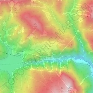
Name: Lateis / Latais topographic map, elevation, terrain.
Average elevation: 4,127 ft
Minimum elevation: 2,352 ft
Maximum elevation: 5,873 ft
Make a donation
Gear up for your next adventure:
As an Amazon Associate, this site earns from qualifying purchases at no extra cost to you.
Other topographic maps
Click on a map to view its topography, its elevation and its terrain.
Tarvisio / Tarvis / Trbiž
Italy > Friuli – Venezia Giulia > Udine / Udin / Videm
Average elevation: 4,160 ft
Make a donation
Gear up for your next adventure:
As an Amazon Associate, this site earns from qualifying purchases at no extra cost to you.
Basiliano / Pasian Sclavonesc
Italy > Friuli – Venezia Giulia > Udine / Udin / Videm
The municipality is located in the Middle Friuli region, on the high Friulian plain, at an average altitude of 77 meters above sea level, and is approximately 13 km from both Udine and Codroipo.
Average elevation: 249 ft
Sauris / Zahre
Italy > Friuli – Venezia Giulia > Udine / Udin / Videm
Sauris (German: Zahre) is a comune (municipality) in the Regional decentralization entity of Udine in the Italian region of Friuli-Venezia Giulia. At an elevation of 1,212 m (3,976 ft), it is the second highest municipality in the region and one of the German language islands in Northeast Italy. Sauris is part…
Average elevation: 4,813 ft
Make a donation
Gear up for your next adventure:
As an Amazon Associate, this site earns from qualifying purchases at no extra cost to you.
Mortegliano / Mortean
Italy > Friuli – Venezia Giulia > Udine / Udin / Videm
Average elevation: 131 ft
San Pietro al Natisone
Italy > Friuli – Venezia Giulia > Udine / Udin / Videm
Average elevation: 1,165 ft
Make a donation
Gear up for your next adventure:
As an Amazon Associate, this site earns from qualifying purchases at no extra cost to you.
Pontebba / Ponteibe / Pontafel / Tablija
Italy > Friuli – Venezia Giulia > Udine / Udin / Videm
Average elevation: 4,229 ft
Tarvisio / Tarvis / Trbiž
Italy > Friuli – Venezia Giulia > Udine / Udin / Videm
Average elevation: 4,160 ft