
Make a donation
Gear up for your next adventure:
As an Amazon Associate, this site earns from qualifying purchases at no extra cost to you.
Ovaro / Davâr topographic map
Click on the map to display elevation.
Make a donation
Gear up for your next adventure:
As an Amazon Associate, this site earns from qualifying purchases at no extra cost to you.
About this map
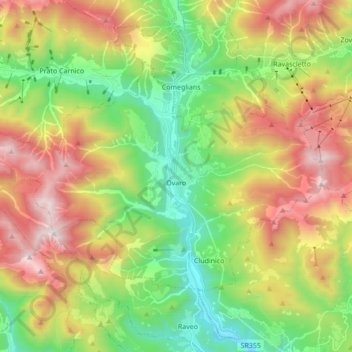
Name: Ovaro / Davâr topographic map, elevation, terrain.
Average elevation: 3,510 ft
Minimum elevation: 1,270 ft
Maximum elevation: 6,699 ft
Make a donation
Gear up for your next adventure:
As an Amazon Associate, this site earns from qualifying purchases at no extra cost to you.
Other topographic maps
Click on a map to view its topography, its elevation and its terrain.
Albana / Ibána / Albane
Italy > Friuli – Venezia Giulia > Udine / Udin / Videm > Prepotto / Prapotno / Prepot
Average elevation: 574 ft
Scale / Skale
Italy > Friuli – Venezia Giulia > Udine / Udin / Videm > Drenchia
Average elevation: 2,001 ft
Montemaggiore / Brezje
Italy > Friuli – Venezia Giulia > Udine / Udin / Videm > Taipana
Average elevation: 2,680 ft
Make a donation
Gear up for your next adventure:
As an Amazon Associate, this site earns from qualifying purchases at no extra cost to you.
Raccolana / Racolane
Italy > Friuli – Venezia Giulia > Udine / Udin / Videm
Average elevation: 2,523 ft
Monte Tamai
Italy > Friuli – Venezia Giulia > Udine / Udin / Videm > Ovaro / Davâr
Average elevation: 5,210 ft
Monte Lubia / Ljubija
Italy > Friuli – Venezia Giulia > Udine / Udin / Videm > Pulfero
Average elevation: 2,608 ft
Make a donation
Gear up for your next adventure:
As an Amazon Associate, this site earns from qualifying purchases at no extra cost to you.
Sandrine
Italy > Friuli – Venezia Giulia > Udine / Udin / Videm > Artegna / Dartigne > Borc dal Steli
Average elevation: 863 ft