
Make a donation
Gear up for your next adventure:
As an Amazon Associate, this site earns from qualifying purchases at no extra cost to you.
Clarence-Rockland topographic map
Click on the map to display elevation.
Make a donation
Gear up for your next adventure:
As an Amazon Associate, this site earns from qualifying purchases at no extra cost to you.
About this map
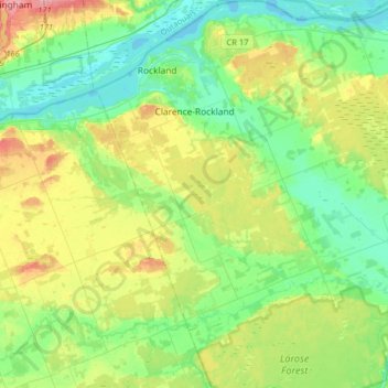
Name: Clarence-Rockland topographic map, elevation, terrain.
Average elevation: 233 ft
Minimum elevation: 125 ft
Maximum elevation: 469 ft
Make a donation
Gear up for your next adventure:
As an Amazon Associate, this site earns from qualifying purchases at no extra cost to you.
Other topographic maps
Click on a map to view its topography, its elevation and its terrain.
Bourget
Canada > Ontario > Prescott and Russell Counties > Clarence-Rockland
Average elevation: 203 ft
Chute-à-Blondeau
Canada > Ontario > Prescott and Russell Counties > East Hawkesbury
Average elevation: 184 ft
Make a donation
Gear up for your next adventure:
As an Amazon Associate, this site earns from qualifying purchases at no extra cost to you.
Saint-Eugène
Canada > Ontario > Prescott and Russell Counties > East Hawkesbury
Average elevation: 194 ft
Fournier
Canada > Ontario > Prescott and Russell Counties > The Nation > Fournier
Average elevation: 187 ft
Clarence Creek
Canada > Ontario > Prescott and Russell Counties > Clarence-Rockland
Average elevation: 217 ft
Make a donation
Gear up for your next adventure:
As an Amazon Associate, this site earns from qualifying purchases at no extra cost to you.
Lefaivre
Canada > Ontario > Prescott and Russell Counties > Alfred and Plantagenet
Average elevation: 164 ft
Hammond
Canada > Ontario > Prescott and Russell Counties > Clarence-Rockland
Average elevation: 233 ft
Alfred
Canada > Ontario > Prescott and Russell Counties > Alfred and Plantagenet
Average elevation: 210 ft
Make a donation
Gear up for your next adventure:
As an Amazon Associate, this site earns from qualifying purchases at no extra cost to you.
Saint-Bernardin
Canada > Ontario > Prescott and Russell Counties > The Nation
Average elevation: 210 ft
Clarence Point
Canada > Ontario > Prescott and Russell Counties > Clarence-Rockland > Clarence Point
Average elevation: 200 ft
Make a donation
Gear up for your next adventure:
As an Amazon Associate, this site earns from qualifying purchases at no extra cost to you.
St. Albert
Canada > Ontario > Prescott and Russell Counties > The Nation > St. Albert
Average elevation: 217 ft
Caledonia Springs
Canada > Ontario > Prescott and Russell Counties > The Nation
Average elevation: 167 ft
Alfred
Canada > Ontario > Prescott and Russell Counties > Alfred and Plantagenet
Average elevation: 210 ft
Make a donation
Gear up for your next adventure:
As an Amazon Associate, this site earns from qualifying purchases at no extra cost to you.
Saint-Eugène
Canada > Ontario > Prescott and Russell Counties > East Hawkesbury
Average elevation: 194 ft
Make a donation
Gear up for your next adventure:
As an Amazon Associate, this site earns from qualifying purchases at no extra cost to you.