Geolocate

Bourget topographic map

Click on the map to display elevation.

About this map

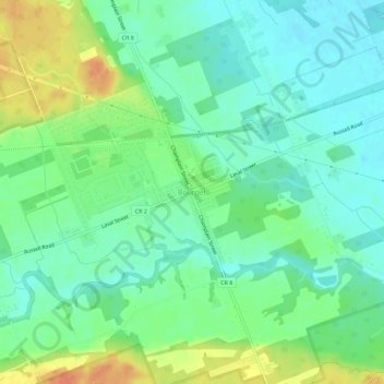
Name: Bourget topographic map, elevation, terrain.

Location: Bourget, Clarence-Rockland, Prescott and Russell Counties, Eastern Ontario, Ontario, K0A 1E0, Canada (45.41488 -75.17789 45.45488 -75.13789)

Average elevation: 203 ft

Minimum elevation: 154 ft

Maximum elevation: 292 ft

Other topographic maps

Click on a map to view its topography, its elevation and its terrain.

Gear up for your next adventure:

🔭Stargazing Telescopes - Perfect for camping in low-light pollution areas shown on maps
💧Water Filtration Bottles - Safely drink from streams and lakes while exploring
🛡️Bear Spray Outdoor - Protection in bear country hikes
🚑Emergency Bivvies - Heat-reflective sleeping bags for survival situations
📡GPS Antenna Upgrade - Enhance GPS reception in remote terrain

As an Amazon Associate, this site earns from qualifying purchases at no extra cost to you.