Geolocate

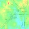
Macedonia topographic map

Click on the map to display elevation.

About this map

Name: Macedonia topographic map, elevation, terrain.

Location: Macedonia, Hamilton County, Illinois, United States (38.04875 -88.71026 38.05634 -88.70031)

Average elevation: 472 ft

Minimum elevation: 410 ft

Maximum elevation: 558 ft

Hamilton County trails, hiking, mountain biking, running and outdoor activities

Other topographic maps

Click on a map to view its topography, its elevation and its terrain.
University

United States > Illinois > Hamilton County

Average elevation: 449 ft

Gear up for your next adventure:

💧Water Filtration Bottles - Safely drink from streams and lakes while exploring
🥘Titanium Cookware - Durable, featherlight pots and pans for backpacking
🌐World Map Poster - Decorative world maps with topographic info
🚪Portable Camp Chair - Foldable chair for comfort at camp
😴Insulated Sleeping Pads - Compact and warm pads for high-elevation camping

As an Amazon Associate, this site earns from qualifying purchases at no extra cost to you.