Geolocate

University topographic map

Click on the map to display elevation.

About this map

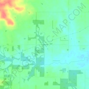
Name: University topographic map, elevation, terrain.

Location: University, Hamilton County, Illinois, United States (37.91644 -88.62950 37.95644 -88.58950)

Average elevation: 449 ft

Minimum elevation: 394 ft

Maximum elevation: 587 ft

Hamilton County trails, hiking, mountain biking, running and outdoor activities

Other topographic maps

Click on a map to view its topography, its elevation and its terrain.

Macedonia

United States > Illinois > Hamilton County

Average elevation: 472 ft

Broughton

United States > Illinois > Hamilton County

Average elevation: 387 ft

Dahlgren

United States > Illinois > Hamilton County

Average elevation: 486 ft

Gear up for your next adventure:

🧥Waterproof Jacket for Hiking - Breathable and rugged rain jacket for outdoor excursions
🛶Inflatable Kayak - Portable kayak for rivers, lakes, and expeditions
Backpacking Tent - Lightweight and durable tent for multi‑day hikes
📶Satellite Messenger - Communication device off‑grid
🔊Portable Camp Speaker - Music and alerts at camp

As an Amazon Associate, this site earns from qualifying purchases at no extra cost to you.