Geolocate

Springville topographic map

Click on the map to display elevation.

About this map

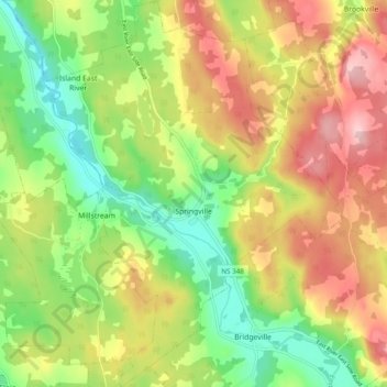
Name: Springville topographic map, elevation, terrain.

Location: Springville, Municipality of Pictou County, Pictou County, Nova Scotia, Canada (45.42341 -62.66143 45.49170 -62.58605)

Average elevation: 420 ft

Minimum elevation: 115 ft

Maximum elevation: 778 ft

Other topographic maps

Click on a map to view its topography, its elevation and its terrain.

Gear up for your next adventure:

🏔️Mountain Trail Maps - High‑detail maps for popular peaks
🛏️Cold Weather Sleeping Bag - Warm sleeping bag for cold conditions
🧭Compass with Lanyard - Easy‑carry compass for navigation
🦺Reflective Outdoor Gear - Safety gear for low‑light conditions
🚗GPS Dash Cams - Record your scenic drives through mountain passes and canyons

As an Amazon Associate, this site earns from qualifying purchases at no extra cost to you.