
Bournemouth topographic map
Click on the map to display elevation.
About this map
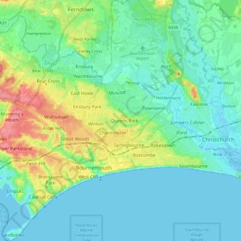
Name: Bournemouth topographic map, elevation, terrain.
Average elevation: 56 ft
Minimum elevation: -10 ft
Maximum elevation: 223 ft
Other topographic maps
Click on a map to view its topography, its elevation and its terrain.
East Parley Common
United Kingdom > England > Bournemouth, Christchurch and Poole > Hurn
Average elevation: 43 ft
Highcliffe-on-Sea
United Kingdom > England > Bournemouth, Christchurch and Poole
Average elevation: 62 ft
Hengistbury Head
United Kingdom > England > Bournemouth, Christchurch and Poole > Bournemouth
In 1910 the first international aviation meeting ever held in Britain took place on a specially laid out aerodrome consisting of a mile of grassland between the "Double Dykes" and the nearby village of Tuckton. About twenty pioneer aviators from around the world participated in various competitions including…
Average elevation: 0 ft
Throop
United Kingdom > England > Bournemouth, Christchurch and Poole > Bournemouth
Average elevation: 43 ft
Kinson
United Kingdom > England > Bournemouth, Christchurch and Poole > Bournemouth
Average elevation: 85 ft
Upton Heath Nature Reserve
United Kingdom > England > Bournemouth, Christchurch and Poole > Poole
Average elevation: 131 ft
Bear Cross
United Kingdom > England > Bournemouth, Christchurch and Poole > Bournemouth
Average elevation: 98 ft
St Catherine's Hill
United Kingdom > England > Bournemouth, Christchurch and Poole > Christchurch
Average elevation: 33 ft
Redhill Park
United Kingdom > England > Bournemouth, Christchurch and Poole > Bournemouth > Talbot Village
Average elevation: 108 ft
Merley
United Kingdom > England > Bournemouth, Christchurch and Poole > Poole
Average elevation: 112 ft
Hamworthy Park
United Kingdom > England > Bournemouth, Christchurch and Poole > Poole
Average elevation: 7 ft
Kings Park
United Kingdom > England > Bournemouth, Christchurch and Poole > Bournemouth
Average elevation: 102 ft
Holes Bay
United Kingdom > England > Bournemouth, Christchurch and Poole > Poole
Average elevation: 13 ft
Island in the Stour
United Kingdom > England > Bournemouth, Christchurch and Poole > Poole > Merley
Average elevation: 92 ft
Holdenhurst
United Kingdom > England > Bournemouth, Christchurch and Poole > Bournemouth
Average elevation: 39 ft