
Poole topographic map
Click on the map to display elevation.
About this map
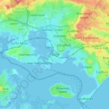
Name: Poole topographic map, elevation, terrain.
Average elevation: 52 ft
Minimum elevation: -23 ft
Maximum elevation: 285 ft
Other topographic maps
Click on a map to view its topography, its elevation and its terrain.
Christchurch
United Kingdom > England > Bournemouth, Christchurch and Poole > Hurn
Average elevation: 59 ft
East Parley Common
United Kingdom > England > Bournemouth, Christchurch and Poole > Hurn
Average elevation: 43 ft
Upton Heath Nature Reserve
United Kingdom > England > Bournemouth, Christchurch and Poole > Poole
Average elevation: 131 ft
Redhill Park
United Kingdom > England > Bournemouth, Christchurch and Poole > Bournemouth > Talbot Village
Average elevation: 108 ft
Hamworthy Park
United Kingdom > England > Bournemouth, Christchurch and Poole > Poole
Average elevation: 7 ft
Kings Park
United Kingdom > England > Bournemouth, Christchurch and Poole > Bournemouth
Average elevation: 102 ft
Christchurch
United Kingdom > England > Bournemouth, Christchurch and Poole > Christchurch
Average elevation: 26 ft
Christchurch
United Kingdom > England > Bournemouth, Christchurch and Poole > Christchurch
Average elevation: 59 ft
Christchurch
United Kingdom > England > Bournemouth, Christchurch and Poole > Hurn
Average elevation: 59 ft
Island in the Stour
United Kingdom > England > Bournemouth, Christchurch and Poole > Poole > Merley
Average elevation: 92 ft
Christchurch
United Kingdom > England > Bournemouth, Christchurch and Poole > Hurn
Average elevation: 59 ft