Geolocate

Indialantic topographic map

Interactive map

Click on the map to display elevation.

About this map

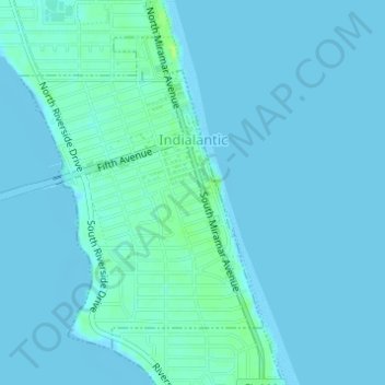
Name: Indialantic topographic map, elevation, terrain.

Location: Indialantic, Brevard County, Florida, United States (28.07678 -80.58004 28.09867 -80.56070)

Average elevation: 7 ft

Minimum elevation: -7 ft

Maximum elevation: 39 ft

Brevard County trails, hiking, mountain biking, running and outdoor activities

Other topographic maps

Click on a map to view its topography, its elevation and its terrain.

Melbourne

United States > Florida > Brevard County > Melbourne

Average elevation: 13 ft

Merritt Island

United States > Florida > Brevard County > Cocoa

Average elevation: 13 ft

Viera

United States > Florida > Brevard County

Average elevation: 30 ft

Merritt Island

United States > Florida > Brevard County

Average elevation: 10 ft

Scottsmoor

United States > Florida > Brevard County

Average elevation: 20 ft

Mims

United States > Florida > Brevard County > Titusville

Average elevation: 13 ft

Cocoa West

United States > Florida > Brevard County

Average elevation: 26 ft

Cape Canaveral

United States > Florida > Brevard County

The hurricane of August 1885, pushed a "wall of water" over the barrier island (elevation, 3.1 m (10 ft)) devastating Cape Canaveral and adjacent areas. The ocean waves flooded the homesteaders and discouraged further settlement in the area. The beach near the lighthouse was severely eroded prompting its…

Average elevation: 3 ft

Suntree

United States > Florida > Brevard County > Suntree

Average elevation: 33 ft

Micco

United States > Florida > Brevard County

Average elevation: 20 ft

Port Saint John

United States > Florida > Brevard County

Average elevation: 30 ft

Hopkins

United States > Florida > Brevard County > Melbourne

Average elevation: 16 ft