
Make a donation
Gear up for your next adventure:
As an Amazon Associate, this site earns from qualifying purchases at no extra cost to you.
Tiris Zemmour topographic map
Click on the map to display elevation.
Make a donation
Gear up for your next adventure:
As an Amazon Associate, this site earns from qualifying purchases at no extra cost to you.
Tiris Zemmour
Mauritania is mostly covered with desert, with only its western regions around the coast of Atlantic Ocean having some vegetation. There are some oasis in the desert regions. Since it is a desert, there are large shifting dunes forming temporary ranges. The average elevation is around 460 m (1,510 ft) above the mean sea level. The rainfall in the northern regions closer to the Tropic of Cancer is around 100 mm (3.9 in) annually, compared to the southern portions that receives around 660 mm (26 in). The average temperature is 37.8 °C (100.0 °F), while during the night it reaches 0 °C (32 °F).
Make a donation
Gear up for your next adventure:
As an Amazon Associate, this site earns from qualifying purchases at no extra cost to you.
About this map
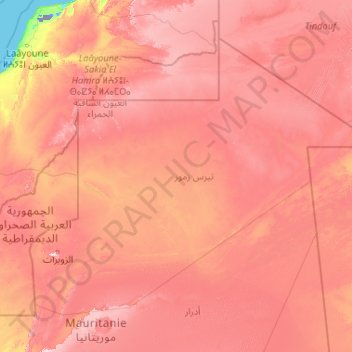
Name: Tiris Zemmour topographic map, elevation, terrain.
Location: Tiris Zemmour, Mauritania (21.34697 -13.15029 27.31494 -4.83333)
Average elevation: 1,066 ft
Minimum elevation: -197 ft
Maximum elevation: 2,746 ft
Make a donation
Gear up for your next adventure:
As an Amazon Associate, this site earns from qualifying purchases at no extra cost to you.
Other topographic maps
Click on a map to view its topography, its elevation and its terrain.
Make a donation
Gear up for your next adventure:
As an Amazon Associate, this site earns from qualifying purchases at no extra cost to you.
Make a donation
Gear up for your next adventure:
As an Amazon Associate, this site earns from qualifying purchases at no extra cost to you.
Make a donation
Gear up for your next adventure:
As an Amazon Associate, this site earns from qualifying purchases at no extra cost to you.
Make a donation
Gear up for your next adventure:
As an Amazon Associate, this site earns from qualifying purchases at no extra cost to you.
Make a donation
Gear up for your next adventure:
As an Amazon Associate, this site earns from qualifying purchases at no extra cost to you.
Make a donation
Gear up for your next adventure:
As an Amazon Associate, this site earns from qualifying purchases at no extra cost to you.
Make a donation
Gear up for your next adventure:
As an Amazon Associate, this site earns from qualifying purchases at no extra cost to you.
Make a donation
Gear up for your next adventure:
As an Amazon Associate, this site earns from qualifying purchases at no extra cost to you.
Make a donation
Gear up for your next adventure:
As an Amazon Associate, this site earns from qualifying purchases at no extra cost to you.