Geolocate

Fulton topographic map

Click on the map to display elevation.

About this map

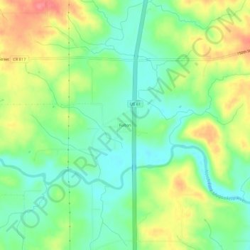
Name: Fulton topographic map, elevation, terrain.

Location: Fulton, Jackson County, Iowa, United States (42.13363 -90.69819 42.17363 -90.65819)

Average elevation: 758 ft

Minimum elevation: 659 ft

Maximum elevation: 906 ft

Jackson County trails, hiking, mountain biking, running and outdoor activities

Other topographic maps

Click on a map to view its topography, its elevation and its terrain.

Bellevue

United States > Iowa > Jackson County

Average elevation: 682 ft

Miles

United States > Iowa > Jackson County

Average elevation: 814 ft

Bellevue

United States > Iowa > Jackson County

Average elevation: 682 ft

Springbrook

United States > Iowa > Jackson County

Average elevation: 801 ft

Springbrook

United States > Iowa > Jackson County

Average elevation: 801 ft

Preston

United States > Iowa > Jackson County

Average elevation: 679 ft

Miles

United States > Iowa > Jackson County

Average elevation: 814 ft

Maquoketa

United States > Iowa > Jackson County

Average elevation: 719 ft

Gear up for your next adventure:

🪶Trail Camera - Capture wildlife on your hikes
🪓Survival Multi‑Tool - Versatile tool for camp and trail tasks
🛰️Satellite Messengers - Emergency SOS and two-way messaging for off-grid adventures
🔥Camping Stove - Portable stove for camping and backcountry cooking
🪵Folding Camp Saw - Compact saw for wood and campsite work

As an Amazon Associate, this site earns from qualifying purchases at no extra cost to you.