Geolocate

Big Water topographic map

Click on the map to display elevation.

About this map

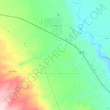
Name: Big Water topographic map, elevation, terrain.

Location: Big Water, Kane County, Utah, United States (37.04869 -111.68790 37.09222 -111.63364)

Average elevation: 4,209 ft

Minimum elevation: 3,816 ft

Maximum elevation: 4,928 ft

Kane County trails, hiking, mountain biking, running and outdoor activities

Other topographic maps

Click on a map to view its topography, its elevation and its terrain.

Duck Creek Village

United States > Utah > Kane County

Average elevation: 8,556 ft

Bald Knoll

United States > Utah > Kane County

Average elevation: 6,640 ft

Millet Point

United States > Utah > Kane County

Average elevation: 6,913 ft

Navajo Lake Lodge

United States > Utah > Kane County

Average elevation: 9,321 ft

Coyote Natural Bridge

United States > Utah > Kane County

Average elevation: 4,465 ft

Rainbow Point

United States > Utah > Kane County

Average elevation: 8,458 ft

Duck Creek Village

United States > Utah > Kane County

Average elevation: 8,556 ft

Gear up for your next adventure:

🧦Hiking Socks - Comfortable socks to prevent blisters on long hikes
🔦LED Headlamp - Bright and durable LED headlamp for night navigation
🧢Sun Protection Hats - Wide-brimmed and UPF-rated hats for high-altitude sun safety
🔥Plasma Lighters - Windproof lighters that work in any weather condition
🛡️Bear Spray Outdoor - Protection in bear country hikes

As an Amazon Associate, this site earns from qualifying purchases at no extra cost to you.