Geolocate

Pishan County topographic map

Click on the map to display elevation.

About this map

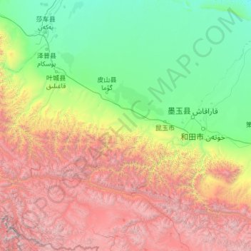
Name: Pishan County topographic map, elevation, terrain.

Location: Pishan County, Hotan Prefecture, Xinjiang, China (35.43918 77.39919 38.83169 79.57672)

Average elevation: 9,380 ft

Minimum elevation: 3,770 ft

Maximum elevation: 26,181 ft

Other topographic maps

Click on a map to view its topography, its elevation and its terrain.

Kilian

China > Xinjiang > Pishan County

Average elevation: 7,277 ft

Gear up for your next adventure:

🧣Merino Neck Gaiters - Multi-functional headwear for wind and sun protection
🥄Camping Utensil Set - Lightweight utensils for outdoor meals
🧭Map Reading Tools - Tools and kits for map navigation
🪑Ultralight Camp Chairs - Portable seating for resting after a long day of mapping
🔌USB Car Charger - Car charger for on‑the‑go power needs

As an Amazon Associate, this site earns from qualifying purchases at no extra cost to you.