
Make a donation
Gear up for your next adventure:
As an Amazon Associate, this site earns from qualifying purchases at no extra cost to you.
San Rafael topographic map
Click on the map to display elevation.
Make a donation
Gear up for your next adventure:
As an Amazon Associate, this site earns from qualifying purchases at no extra cost to you.
About this map
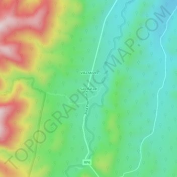
Name: San Rafael topographic map, elevation, terrain.
Average elevation: 3,668 ft
Minimum elevation: 3,136 ft
Maximum elevation: 4,728 ft
Make a donation
Gear up for your next adventure:
As an Amazon Associate, this site earns from qualifying purchases at no extra cost to you.
Other topographic maps
Click on a map to view its topography, its elevation and its terrain.
Municipio de Palpalá
Palpalá es una ciudad argentina, cabecera del departamento homónimo, ubicada a 13 km al sudeste de la ciudad capital de San Salvador de Jujuy y a 1686 km de la ciudad de Buenos Aires, a una altitud de 1125 m s. n. m.
Average elevation: 4,485 ft
Make a donation
Gear up for your next adventure:
As an Amazon Associate, this site earns from qualifying purchases at no extra cost to you.
Municipio de San Salvador de Jujuy
San Salvador de Jujuy ostenta dos récords nacionales: por su latitud, sobre el paralelo de 24°11'08'', es la capital de provincia más septentrional de la Argentina y por su altitud, a 1.259 msnm, es también la capital de provincia más alta del país.
Average elevation: 6,276 ft
Make a donation
Gear up for your next adventure:
As an Amazon Associate, this site earns from qualifying purchases at no extra cost to you.
Make a donation
Gear up for your next adventure:
As an Amazon Associate, this site earns from qualifying purchases at no extra cost to you.
Yuto
El área de influencia de la EECT Yuto abarca las Yungas y la parte occidental del Chaco Semiárido, con 730.000 ha. Comprende los valles del río San Francisco, del río Bermejo y del Zenta, en el norte de las provincias de Salta y Jujuy, con altitudes que van desde los 300 m s. n. m. hasta 1800 m s. n. m.
Average elevation: 1,138 ft
Make a donation
Gear up for your next adventure:
As an Amazon Associate, this site earns from qualifying purchases at no extra cost to you.
Municipio de Rinconada
Por su altitud de 4320 m s. n. m., es una de las localidades más elevadas de la República Argentina.
Average elevation: 12,920 ft
Municipio de Yavi
Se ubica a una altitud de 3516 m s. n. m. El 18 de febrero de 1975, la localidad de Yavi fue declarada “Lugar Histórico” mediante Decreto 370/1975.
Average elevation: 11,913 ft
Municipio de Humahuaca
Humahuaca tiene un clima árido fresco (Köppen BWK), con dos temporadas: un verano suave con tormentas eléctricas ocasionales de diciembre a marzo, y un invierno fresco, extremadamente claro y sin lluvias que cubre el resto del año. Aunque las tardes son cálidas durante todo el año, la altitud extrema…
Average elevation: 11,969 ft
Make a donation
Gear up for your next adventure:
As an Amazon Associate, this site earns from qualifying purchases at no extra cost to you.
Quebrada de Humahuaca
Por el suroeste y por el sur, la Quebrada de Humahuaca desciende en altitud y se relaciona a través de valles intermedios como el de Lerma, con la Quebrada del Toro que desciende desde el Oeste (es decir, desde el Altiplano) y con los también célebres Valles Calchaquíes.
Average elevation: 9,908 ft
Parque Nacional Calilegua
En la franja altitudinal superior (700-1500 m sobre el nivel del mar) aparece la selva montana que en gran parte es una nimbosilva, la cual ocupa la mayor superficie del Parque Calilegua. Esta selva se caracterizada por la presencia de laurel (Cinnamomum porphyrium), ceibo (Erythrina falcata), cedro colla…
Average elevation: 3,734 ft
Make a donation
Gear up for your next adventure:
As an Amazon Associate, this site earns from qualifying purchases at no extra cost to you.
Municipio de Maimará
Maimará se encuentra a una altitud de 2,334 m s. n. m. (metros sobre el nivel del mar) en la quebrada de Humahuaca, a 76 km de la capital de la provincia —San Salvador de Jujuy— con fácil acceso por la ruta nacional RN9.
Average elevation: 10,587 ft
Make a donation
Gear up for your next adventure:
As an Amazon Associate, this site earns from qualifying purchases at no extra cost to you.
Make a donation
Gear up for your next adventure:
As an Amazon Associate, this site earns from qualifying purchases at no extra cost to you.
Olaroz Chico
Se encuentra en la puna jujeña, a una altitud de 4165 m s. n. m.
Average elevation: 13,825 ft
Make a donation
Gear up for your next adventure:
As an Amazon Associate, this site earns from qualifying purchases at no extra cost to you.
Municipio de Santa Catalina
Argentina > Jujuy > Municipio de Santa Catalina
Average elevation: 12,575 ft
Make a donation
Gear up for your next adventure:
As an Amazon Associate, this site earns from qualifying purchases at no extra cost to you.
Make a donation
Gear up for your next adventure:
As an Amazon Associate, this site earns from qualifying purchases at no extra cost to you.
Parque Provincial Potrero de Yala
Argentina > Jujuy > Municipio de Yala
En Yala los veranos son más lluviosos que los inviernos. La temperatura promedio es 16.4 °C y las precipitaciones promedio de 765 mm. El clima de Yala corresponde a la región de los “valles”, caracterizado como templado lluvioso, con veranos calurosos y húmedos e inviernos secos y fríos. Las…
Average elevation: 8,012 ft
Make a donation
Gear up for your next adventure:
As an Amazon Associate, this site earns from qualifying purchases at no extra cost to you.
Make a donation
Gear up for your next adventure:
As an Amazon Associate, this site earns from qualifying purchases at no extra cost to you.
Municipio de Palpalá
Palpalá es una ciudad argentina, cabecera del departamento homónimo, ubicada a 13 km al sudeste de la ciudad capital de San Salvador de Jujuy y a una altitud de 1125 m s. n. m.
Average elevation: 4,485 ft
Quebrada de Humahuaca
Por el suroeste y por el sur, la Quebrada de Humahuaca desciende en altitud y se relaciona a través de valles intermedios como el de Lerma, con la Quebrada del Toro que desciende desde el Oeste (es decir, desde el Altiplano) y con los también célebres Valles Calchaquíes.
Average elevation: 9,908 ft
Make a donation
Gear up for your next adventure:
As an Amazon Associate, this site earns from qualifying purchases at no extra cost to you.
Municipio de Palpalá
Palpalá es una ciudad argentina, cabecera del departamento homónimo, ubicada a 13 km al sudeste de la ciudad capital de San Salvador de Jujuy y a una altitud de 1125 m s. n. m.
Average elevation: 4,485 ft
Municipio de Humahuaca
Humahuaca tiene un clima árido fresco (Köppen BWK), con dos temporadas: un verano suave con tormentas eléctricas ocasionales de diciembre a marzo, y un invierno fresco, extremadamente claro y sin lluvias que cubre el resto del año. Aunque las tardes son cálidas durante todo el año, la altitud extrema…
Average elevation: 11,969 ft
Make a donation
Gear up for your next adventure:
As an Amazon Associate, this site earns from qualifying purchases at no extra cost to you.
Parque Provincial Potrero de Yala
Argentina > Jujuy > Municipio de Yala
En Yala los veranos son más lluviosos que los inviernos. La temperatura promedio es 16.4 °C y las precipitaciones promedio de 765 mm. El clima de Yala corresponde a la región de los “valles”, caracterizado como templado lluvioso, con veranos calurosos y húmedos e inviernos secos y fríos. Las…
Average elevation: 8,012 ft
Asentamiento Xibi Xibi
Argentina > Jujuy > Municipio de San Salvador de Jujuy
Average elevation: 4,081 ft
Make a donation
Gear up for your next adventure:
As an Amazon Associate, this site earns from qualifying purchases at no extra cost to you.
Municipio de San Salvador de Jujuy
San Salvador de Jujuy ostenta dos récords nacionales: por su latitud, sobre el paralelo de 24°11'08'', es la capital de provincia más septentrional de la Argentina. Y por su altitud, a 1259 msnm, es también la capital de provincia más alta del país.
Average elevation: 6,276 ft
Make a donation
Gear up for your next adventure:
As an Amazon Associate, this site earns from qualifying purchases at no extra cost to you.
Municipio de Humahuaca
Humahuaca tiene un clima árido fresco (Köppen BWK), con dos temporadas: un verano suave con tormentas eléctricas ocasionales de diciembre a marzo, y un invierno fresco, extremadamente claro y sin lluvias que cubre el resto del año. Aunque las tardes son cálidas durante todo el año, la altitud extrema…
Average elevation: 11,969 ft
Make a donation
Gear up for your next adventure:
As an Amazon Associate, this site earns from qualifying purchases at no extra cost to you.
Make a donation
Gear up for your next adventure:
As an Amazon Associate, this site earns from qualifying purchases at no extra cost to you.
Make a donation
Gear up for your next adventure:
As an Amazon Associate, this site earns from qualifying purchases at no extra cost to you.
Municipio de Humahuaca
Humahuaca tiene un clima árido fresco (Köppen BWK), con dos temporadas: un verano suave con tormentas eléctricas ocasionales de diciembre a marzo, y un invierno fresco, extremadamente claro y sin lluvias que cubre el resto del año. Aunque las tardes son cálidas durante todo el año, la altitud extrema…
Average elevation: 11,969 ft
Make a donation
Gear up for your next adventure:
As an Amazon Associate, this site earns from qualifying purchases at no extra cost to you.
Municipio de Humahuaca
Humahuaca tiene un clima árido fresco (Köppen BWK), con dos temporadas: un verano suave con tormentas eléctricas ocasionales de diciembre a marzo, y un invierno fresco, extremadamente claro y sin lluvias que cubre el resto del año. Aunque las tardes son cálidas durante todo el año, la altitud extrema…
Average elevation: 11,969 ft
Municipio de San Salvador de Jujuy
San Salvador de Jujuy ostenta dos récords nacionales: por su latitud, sobre el paralelo de 24°11'08'', es la capital de provincia más septentrional de la Argentina. Y por su altitud, a 1259 msnm, es también la capital de provincia más alta del país.
Average elevation: 6,276 ft
Municipio de San Salvador de Jujuy
San Salvador de Jujuy ostenta dos récords nacionales: por su latitud, sobre el paralelo de 24°11'08'', es la capital de provincia más septentrional de la Argentina. Y por su altitud, a 1.259 msnm, es también la capital de provincia más alta del país.
Average elevation: 6,276 ft
Make a donation
Gear up for your next adventure:
As an Amazon Associate, this site earns from qualifying purchases at no extra cost to you.
Municipio de San Salvador de Jujuy
San Salvador de Jujuy ostenta dos récords nacionales: por su latitud, sobre el paralelo de 24°11'08'', es la capital de provincia más septentrional de la Argentina. Y por su altitud, a 1.259 msnm, es también la capital de provincia más alta del país.
Average elevation: 6,276 ft