
Make a donation
Gear up for your next adventure:
As an Amazon Associate, this site earns from qualifying purchases at no extra cost to you.
Voormezele topographic map
Click on the map to display elevation.
Make a donation
Gear up for your next adventure:
As an Amazon Associate, this site earns from qualifying purchases at no extra cost to you.
Voormezele
Voormezele ligt in Zandlemig Vlaanderen, op een hoogte van 22 tot 58 meter. De Diependalebeek en de Wijtschatebeek komen er samen om de Bollaertbeek te vormen. Ten oosten van de kom ligt het domein Palingbeek.
Make a donation
Gear up for your next adventure:
As an Amazon Associate, this site earns from qualifying purchases at no extra cost to you.
About this map
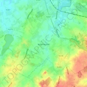
Name: Voormezele topographic map, elevation, terrain.
Location: Voormezele, Ieper, West-Vlaanderen, België (50.79826 2.84699 50.83674 2.92500)
Average elevation: 105 ft
Minimum elevation: 46 ft
Maximum elevation: 203 ft
Make a donation
Gear up for your next adventure:
As an Amazon Associate, this site earns from qualifying purchases at no extra cost to you.
Other topographic maps
Click on a map to view its topography, its elevation and its terrain.
Make a donation
Gear up for your next adventure:
As an Amazon Associate, this site earns from qualifying purchases at no extra cost to you.