Geolocate

Ratanwadi topographic map

Click on the map to display elevation.

About this map

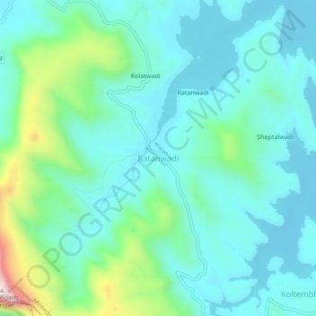
Name: Ratanwadi topographic map, elevation, terrain.

Location: Ratanwadi, Akola, Ahmednagar District, Maharashtra, India (19.49590 73.70330 19.53590 73.74330)

Average elevation: 2,740 ft

Minimum elevation: 2,392 ft

Maximum elevation: 4,111 ft

Other topographic maps

Click on a map to view its topography, its elevation and its terrain.

Borgaon Manju

India > Maharashtra > Akola

Average elevation: 968 ft

Babhulgaon

India > Maharashtra > Akola > Babhulgaon

Average elevation: 965 ft

Dongargaon

India > Maharashtra > Akola > Dongargaon

Average elevation: 965 ft

Pahadpur

India > Maharashtra > Akola

Average elevation: 981 ft

Nawakheda

India > Maharashtra > Akola

Average elevation: 886 ft

Nizampur

India > Maharashtra > Akola

Average elevation: 919 ft

Hingna Barling

India > Maharashtra > Akola

Average elevation: 938 ft

Kothari

India > Maharashtra > Akola

Average elevation: 981 ft

Gear up for your next adventure:

👟Men's Trail Runners - Lightweight footwear for fast-paced exploration and light hiking
🏕️Tent Footprint - Protect your tent base from wear
🛡️Bear Spray Outdoor - Protection in bear country hikes
🕶️Glacier Sunglasses - Side shields to protect eyes from high-altitude snow glare
🔦LED Headlamp - Bright and durable LED headlamp for night navigation

As an Amazon Associate, this site earns from qualifying purchases at no extra cost to you.