Geolocate

Phaplu topographic map

Click on the map to display elevation.

Phaplu

Phaphlu is a mountainous town in north-east Nepal, approximately 270 kilometres east of the Nepalese capital, Kathmandu. The altitude of the village is 2,413 m.

Wikipedia (CC-BY-SA 3.0)

About this map

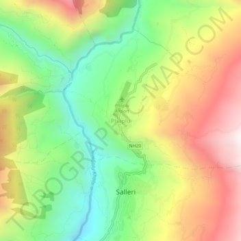
Name: Phaplu topographic map, elevation, terrain.

Location: Phaplu, Dudhkunda, Solududhkunda, Solukhumbu, Province #1, 50600, Nepal (27.49440 86.56489 27.53440 86.60489)

Average elevation: 8,261 ft

Minimum elevation: 6,801 ft

Maximum elevation: 10,046 ft

Gear up for your next adventure:

🔌USB Car Charger - Car charger for on‑the‑go power needs
🧥Men's Rain Shells - Premium waterproof and breathable jackets for mountain weather
🧺Microfiber Travel Towels - Compact and fast-drying towels for trail use
🗺️NatGeo Topo Maps - High-quality waterproof printed topographic maps of US Parks
🪑Ultralight Camp Chairs - Portable seating for resting after a long day of mapping

As an Amazon Associate, this site earns from qualifying purchases at no extra cost to you.