Geolocate

Tampa topographic map

Click on the map to display elevation.

Tampa

Tampa is characterized by a predominantly flat topography, with an average elevation around 16 to 49 feet (5 to 15 meters) above sea level. The terrain is marked by low-lying areas and gentle slopes, with the highest points in the vicinity reaching approximately 62 feet (19 meters). This landscape is interspersed with numerous water bodies, including the expansive Tampa Bay to the west and the Hillsborough River that meanders through the city, contributing to its lush vegetation and diverse ecosystems. The surrounding areas often feature wetlands and marshlands, particularly as one moves toward the coast, creating a rich environment for both wildlife and recreational activities.

About this map

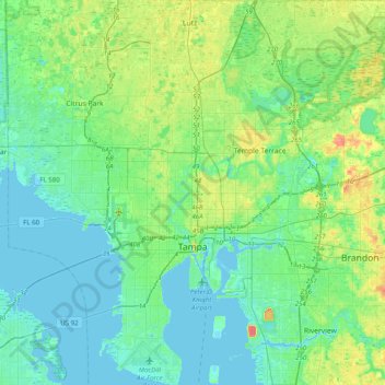
Name: Tampa topographic map, elevation, terrain.

Location: Tampa, Hillsborough County, Florida, United States (27.81265 -82.64882 28.17136 -82.25387)

Average elevation: 36 ft

Minimum elevation: -10 ft

Maximum elevation: 151 ft

Hillsborough County trails, hiking, mountain biking, running and outdoor activities

Other topographic maps

Click on a map to view its topography, its elevation and its terrain.

Ruskin

United States > Florida > Hillsborough County

Average elevation: 23 ft

Valrico

United States > Florida > Hillsborough County > Valrico

Average elevation: 82 ft

Lutz

United States > Florida > Hillsborough County > Tampa

Lutz is characterized by a gently rolling topography that showcases the distinctive features of the central Florida landscape. The area has an average elevation of about 70 feet (21 meters) above sea level, contributing to its mild undulations rather than dramatic elevation changes. The terrain is marked by a…

Average elevation: 66 ft

Riverview

United States > Florida > Hillsborough County

Average elevation: 43 ft

Cairo

United States > Florida > Hillsborough County > Tampa

Average elevation: 33 ft

Tampa Bay

United States > Florida > Hillsborough County

Average elevation: 0 ft

Oakridge

United States > Florida > Hillsborough County > Tampa

Average elevation: 43 ft

Andrea

United States > Florida > Hillsborough County > Tampa

Average elevation: 33 ft

Manhattan

United States > Florida > Hillsborough County > Tampa

Average elevation: 30 ft

Fiorito

United States > Florida > Hillsborough County > Tampa

Average elevation: 49 ft

Meadowlawn

United States > Florida > Hillsborough County > Tampa

Average elevation: 16 ft

Wimauma

United States > Florida > Hillsborough County

Average elevation: 75 ft

Lutz

United States > Florida > Hillsborough County

Average elevation: 69 ft

Brandon

United States > Florida > Hillsborough County

Average elevation: 62 ft

Port Tampa

United States > Florida > Hillsborough County > Tampa

Average elevation: 13 ft

Seffner

United States > Florida > Hillsborough County

Average elevation: 75 ft

Carrollwood

United States > Florida > Hillsborough County > Tampa

Carrollwood is located at 28.1 degrees north, 82.5 degrees west (28.0523, -82.4858). The elevation for the community is 39 feet (12 m) above sea level.

Average elevation: 52 ft

FishHawk

United States > Florida > Hillsborough County > Brandon

Average elevation: 79 ft

Riverside

United States > Florida > Hillsborough County > Tampa

Average elevation: 26 ft

Homelands

United States > Florida > Hillsborough County > Tampa

Average elevation: 46 ft

Wilhelmina

United States > Florida > Hillsborough County > Tampa

Average elevation: 23 ft

Rattlesnake

United States > Florida > Hillsborough County > Tampa

Average elevation: 16 ft

Hammocks

United States > Florida > Hillsborough County > Tampa

Average elevation: 59 ft

Albion

United States > Florida > Hillsborough County > Tampa

Average elevation: 30 ft

Hart Lake

United States > Florida > Hillsborough County > Lutz

Average elevation: 72 ft

Carrollwood

United States > Florida > Hillsborough County

Carrollwood is located at 28.1 degrees north, 82.5 degrees west (28.0523, -82.4858). The elevation for the community is 39 feet (12 m) above sea level.

Average elevation: 52 ft

Westchase

United States > Florida > Hillsborough County

Average elevation: 23 ft

Keystone

United States > Florida > Hillsborough County

Average elevation: 49 ft

Tampa Bay

United States > Florida > Hillsborough County

Average elevation: 0 ft

Lutz

United States > Florida > Hillsborough County > Tampa

Average elevation: 66 ft

Brandon

United States > Florida > Hillsborough County

Average elevation: 62 ft

Wimauma

United States > Florida > Hillsborough County

Average elevation: 75 ft

Valrico

United States > Florida > Hillsborough County

Average elevation: 82 ft

Brandon

United States > Florida > Hillsborough County

Average elevation: 62 ft

Westchase

United States > Florida > Hillsborough County

Average elevation: 23 ft

Andrea

United States > Florida > Hillsborough County > Tampa

Average elevation: 33 ft

Dover

United States > Florida > Hillsborough County > Brandon > Aarons Place

Average elevation: 108 ft

Cairo

United States > Florida > Hillsborough County > Tampa

Average elevation: 33 ft

Allendale

United States > Florida > Hillsborough County > Brandon

Average elevation: 56 ft

Fiorito

United States > Florida > Hillsborough County > Tampa

Average elevation: 49 ft

Oakhurst

United States > Florida > Hillsborough County > Tampa

Average elevation: 59 ft

Estuary

United States > Florida > Hillsborough County > Tampa

Average elevation: 33 ft

Tarpon

United States > Florida > Hillsborough County

Average elevation: 33 ft

FishHawk

United States > Florida > Hillsborough County

Average elevation: 79 ft

Alta Vista

United States > Florida > Hillsborough County > Tampa

Average elevation: 56 ft

Cartertown

United States > Florida > Hillsborough County > Tampa

Average elevation: 46 ft

Deer Park

United States > Florida > Hillsborough County > Lutz

Average elevation: 72 ft

Brandon

United States > Florida > Hillsborough County > Brandon

Average elevation: 62 ft

La Casa

United States > Florida > Hillsborough County > Tampa

Average elevation: 46 ft

West View

United States > Florida > Hillsborough County > Tampa

Average elevation: 16 ft

Egypt Lake-Leto

United States > Florida > Hillsborough County

Egypt Lake-Leto is located in northwestern Hillsborough County at 28°0′55″N 82°30′26″W / 28.01528°N 82.50722°W / 28.01528; -82.50722 (28.015396, -82.507311), 7 miles (11 km) northwest of downtown Tampa. The elevation for the CDP is 45 feet (14 m) above sea level.

Average elevation: 49 ft

Ad Mer

United States > Florida > Hillsborough County > Tampa

Average elevation: 30 ft

Andover

United States > Florida > Hillsborough County

Average elevation: 46 ft

Gear up for your next adventure:

🌎3D Topographic Globes - Raised relief globes for a tactile understanding of geography
🔦Powerful Headlamps - Ultra-bright hands-free lighting for night navigation
🔥Plasma Lighters - Windproof lighters that work in any weather condition
🥾Men's Hiking Boots - Durable, waterproof footwear for rugged terrain and steep inclines
📷Action Cameras - Rugged cameras to document your journeys across rugged terrain

As an Amazon Associate, this site earns from qualifying purchases at no extra cost to you.