
Cephalonia topographic map
Click on the map to display elevation.
Cephalonia
The island's highest mountain is Mount Ainos, with an elevation of 1628 meters; to the west-northwest are the Paliki mountains, where Lixouri is found, with other mountains including Geraneia (Gerania) and Agia Dynati. The top of Mount Ainos is covered with fir trees and is a natural park.
About this map
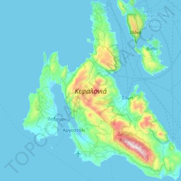
Name: Cephalonia topographic map, elevation, terrain.
Average elevation: 453 ft
Minimum elevation: -7 ft
Maximum elevation: 5,253 ft
Other topographic maps
Click on a map to view its topography, its elevation and its terrain.
Mount Ainos National Park
Greece > Ioanian Islands > Kefallonia Regional Unit > Municipal Unit of Elios-Proni
Average elevation: 1,644 ft
Parisata
Greece > Ioanian Islands > Kefallonia Regional Unit > Paliki Municipal Unit > Monopolata
Average elevation: 817 ft