Geolocate

Wagener topographic map

Click on the map to display elevation.

About this map

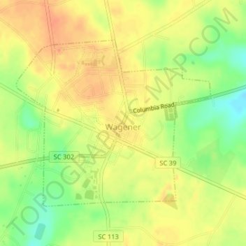
Name: Wagener topographic map, elevation, terrain.

Location: Wagener, Aiken County, South Carolina, United States (33.64363 -81.37530 33.66191 -81.34966)

Average elevation: 449 ft

Minimum elevation: 358 ft

Maximum elevation: 509 ft

Aiken County trails, hiking, mountain biking, running and outdoor activities

Other topographic maps

Click on a map to view its topography, its elevation and its terrain.

Langley

United States > South Carolina > Aiken County > Burnettown

Average elevation: 269 ft

Couchton

United States > South Carolina > Aiken County

Average elevation: 413 ft

Hunters Glen

United States > South Carolina > Aiken County > Aiken

Average elevation: 446 ft

Aiken

United States > South Carolina > Aiken County > Aiken > Aiken

Average elevation: 469 ft

Gear up for your next adventure:

Backpacking Tents - Weight-optimized shelters for multi-day topographic surveys
Camping Coffee Makers - Enjoy premium coffee at the summit or campsite
🧤Tactile Hiking Gloves - Keep hands warm while operating GPS and smartphone screens
🧭Hiking Compass - Precision compass for reliable navigation in the wilderness
🚪Portable Camp Chair - Foldable chair for comfort at camp

As an Amazon Associate, this site earns from qualifying purchases at no extra cost to you.