
Make a donation
Gear up for your next adventure:
As an Amazon Associate, this site earns from qualifying purchases at no extra cost to you.
Mountain View topographic map
Click on the map to display elevation.
Make a donation
Gear up for your next adventure:
As an Amazon Associate, this site earns from qualifying purchases at no extra cost to you.
About this map
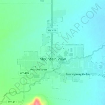
Name: Mountain View topographic map, elevation, terrain.
Location: Mountain View, Uinta County, Wyoming, United States (41.26540 -110.34828 41.28375 -110.31701)
Average elevation: 6,798 ft
Minimum elevation: 6,739 ft
Maximum elevation: 7,031 ft
Uinta County trails, hiking, mountain biking, running and outdoor activities
Make a donation
Gear up for your next adventure:
As an Amazon Associate, this site earns from qualifying purchases at no extra cost to you.
Other topographic maps
Click on a map to view its topography, its elevation and its terrain.
Evanston
United States > Wyoming > Uinta County > Evanston
Evanston is located at 41°15′48″N 110°57′53″W / 41.26333°N 110.96472°W / 41.26333; -110.96472 (41.263302, −110.964616). The elevation is 6749 feet (2057 m) above sea level.
Average elevation: 7,077 ft