
Cambridge topographic map
Interactive map
Click on the map to display elevation.
About this map
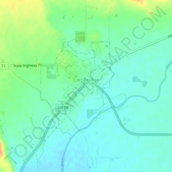
Name: Cambridge topographic map, elevation, terrain.
Location: Cambridge, Washington County, Idaho, United States (44.56460 -116.68610 44.57852 -116.66948)
Average elevation: 2,661 ft
Minimum elevation: 2,621 ft
Maximum elevation: 2,756 ft
Cambridge is located at 44°34′18″N 116°40′41″W / 44.57167°N 116.67806°W / 44.57167; -116.67806 (44.571535, −116.678013), at an elevation of 2,661 feet (811 m) above sea level. According to the United States Census Bureau, the city has a total area of 0.49 square miles (1.27 km2), of which, 0.48 square miles (1.24 km2) is land and 0.01 square miles (0.03 km2) is water.
Other topographic maps
Click on a map to view its topography, its elevation and its terrain.
Midvale
United States > Idaho > Washington County
Midvale, Washington County, Idaho, United States
Average elevation: 2,605 ft
Snake River
United States > Idaho > Washington County
Snake River, Washington County, Idaho, United States
Average elevation: 2,110 ft