
Midvale topographic map
Interactive map
Click on the map to display elevation.
About this map
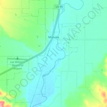
Name: Midvale topographic map, elevation, terrain.
Location: Midvale, Washington County, Idaho, United States (44.43943 -116.76489 44.48811 -116.71933)
Average elevation: 2,605 ft
Minimum elevation: 2,513 ft
Maximum elevation: 2,953 ft
Midvale is at an elevation of 2,543 feet (775 m) above sea level.
Other topographic maps
Click on a map to view its topography, its elevation and its terrain.
Cambridge
United States > Idaho > Washington County
Cambridge, Washington County, Idaho, United States
Average elevation: 2,661 ft
Snake River
United States > Idaho > Washington County
Snake River, Washington County, Idaho, United States
Average elevation: 2,110 ft