Geolocate

Pergola topographic map

Click on the map to display elevation.

About this map

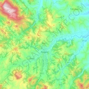
Name: Pergola topographic map, elevation, terrain.

Location: Pergola, Pesaro e Urbino, Marche, 61045, Italy (43.50403 12.74221 43.64622 12.92296)

Average elevation: 1,270 ft

Minimum elevation: 518 ft

Maximum elevation: 3,169 ft

Other topographic maps

Click on a map to view its topography, its elevation and its terrain.

Lucrezia

Italy > Marche > Pesaro e Urbino

Average elevation: 223 ft

San Lazzaro

Italy > Marche > Pesaro e Urbino > Fossombrone

Average elevation: 1,001 ft

Gear up for your next adventure:

🌡️Handheld Weather Meters - Measure wind, temp, and pressure for safe mountain travel
🥾Hiking Shoes - Durable and comfortable shoes for trail hiking
🦶Carbon Trekking Poles - Reduce knee impact on steep descents with ultra-light poles
🎒Trail Energy Bars - High‑calorie bars for hiking energy
🌐World Map Poster - Decorative world maps with topographic info

As an Amazon Associate, this site earns from qualifying purchases at no extra cost to you.