
Make a donation
Gear up for your next adventure:
As an Amazon Associate, this site earns from qualifying purchases at no extra cost to you.
Lucrezia topographic map
Click on the map to display elevation.
Make a donation
Gear up for your next adventure:
As an Amazon Associate, this site earns from qualifying purchases at no extra cost to you.
About this map
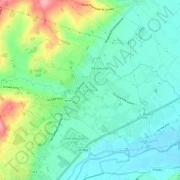
Name: Lucrezia topographic map, elevation, terrain.
Location: Lucrezia, Cartoceto, Pesaro e Urbino, Marche, 61030, Italy (43.75448 12.92021 43.79448 12.96021)
Average elevation: 223 ft
Minimum elevation: 92 ft
Maximum elevation: 541 ft
Make a donation
Gear up for your next adventure:
As an Amazon Associate, this site earns from qualifying purchases at no extra cost to you.
Other topographic maps
Click on a map to view its topography, its elevation and its terrain.
Urbino
Italy > Marche > Pesaro e Urbino
The century began quietly. In addition to the artistic development from the Scuola del Libro, Urbino also began to grow as a university town, with the elevation to university faculty of nineteenth-century School of Pharmacy and the birth of the department of Education (approximately 1934). Due to these changes…
Average elevation: 988 ft
Urbino
Italy > Marche > Pesaro e Urbino
The century began as had the previous one. This period of quiet lasted for almost the entire first half of the twentieth century, with no particular significant events. In this period, the Scuola del Libro (Istituto per la Decorazione e l'Illustrazione del Libro) was founded and expressed considerable talent…
Average elevation: 988 ft
Urbino
Italy > Marche > Pesaro e Urbino
The century began quietly. In addition to the artistic development from the Scuola del Libro, Urbino also began to grow as a university town, with the elevation to university faculty of nineteenth-century School of Pharmacy and the birth of the department of Education (approximately 1934). Due to these changes…
Average elevation: 988 ft
Make a donation
Gear up for your next adventure:
As an Amazon Associate, this site earns from qualifying purchases at no extra cost to you.
Make a donation
Gear up for your next adventure:
As an Amazon Associate, this site earns from qualifying purchases at no extra cost to you.