
Koronadal topographic map
Click on the map to display elevation.
About this map
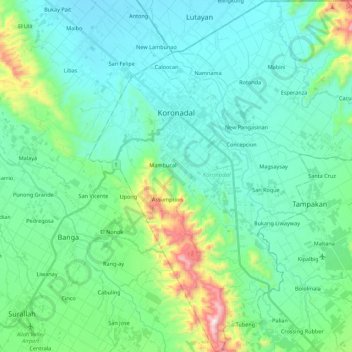
Name: Koronadal topographic map, elevation, terrain.
Location: Koronadal, South Cotabato, Soccsksargen, 9506, Philippines (6.35177 124.78885 6.57630 125.00042)
Average elevation: 538 ft
Minimum elevation: 39 ft
Maximum elevation: 2,651 ft
Other topographic maps
Click on a map to view its topography, its elevation and its terrain.
Lake Sebu
The placid lake of Lake Sebu can be found in Allah Valley near the municipality of Surallah, South Cotabato. Surrounded by rolling hills and mountains covered with thick rain forest, the lake has an area of 361.124 hectares (892.36 acres), with an elevation of approximately 1,000 metres (3,300 ft).
Average elevation: 2,461 ft
Mount Matutum
Philippines > South Cotabato > Tupi
Mount Matutum is an active stratovolcano, is the highest point in the province of South Cotabato in the Philippines, with an elevation of 7,500 feet (2,286 metres) above sea level, approximately 5.7 kilometres (3.5 mi) from Acmonan, Tupi, South Cotabato. Matutum and its foothills are predominantly inhabited by…
Average elevation: 5,443 ft
Mount Matutum
Philippines > South Cotabato > Polomolok
Mount Matutum is an active stratovolcano, is the highest point in the province of South Cotabato in the Philippines, with an elevation of 7,500 feet (2,286 metres) above sea level, approximately 5.7 kilometres (3.5 mi) from Acmonan, Tupi, South Cotabato. Matutum and its foothills are predominantly inhabited by…
Average elevation: 5,443 ft
Lake Sebu
The placid lake of Lake Sebu can be found in Allah Valley near the municipality of Surallah, South Cotabato. Surrounded by rolling hills and mountains covered with thick rain forest, the lake has an area of 354 hectares (870 acres), with an elevation of approximately 1,000 metres (3,300 ft).
Average elevation: 2,461 ft