
Tinugas topographic map
Click on the map to display elevation.
About this map
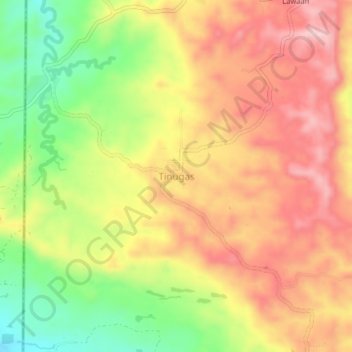
Name: Tinugas topographic map, elevation, terrain.
Location: Tinugas, South Cotabato, Soccsksargen, Philippines (6.30045 124.40585 6.34045 124.44585)
Average elevation: 2,749 ft
Minimum elevation: 2,313 ft
Maximum elevation: 3,100 ft
Other topographic maps
Click on a map to view its topography, its elevation and its terrain.
Lake Sebu
The placid lake of Lake Sebu can be found in Allah Valley near the municipality of Surallah, South Cotabato. Surrounded by rolling hills and mountains covered with thick rain forest, the lake has an area of 361.124 hectares (892.36 acres), with an elevation of approximately 1,000 metres (3,300 ft).
Average elevation: 2,329 ft
Koronadal
The city's landscape features a combination of flatlands and gently sloping terrain, with approximately 50.18% of its total land area classified as predominantly flat. It is flanked by the Roxas and Quezon mountain ranges, whose elevations reach between 700 to 800 meters above sea level and gradually slope…
Average elevation: 538 ft
Lake Sebu
The placid lake of Lake Sebu can be found in Allah Valley near the municipality of Surallah, South Cotabato. Surrounded by rolling hills and mountains covered with thick rain forest, the lake has an area of 361.124 hectares (892.36 acres), with an elevation of approximately 1,000 metres (3,300 ft).
Average elevation: 2,329 ft