Geolocate

Granby topographic map

Click on the map to display elevation.

About this map

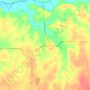
Name: Granby topographic map, elevation, terrain.

Location: Granby, Newton County, Missouri, 64844, United States (36.89690 -94.28360 36.94246 -94.23596)

Average elevation: 1,148 ft

Minimum elevation: 1,014 ft

Maximum elevation: 1,247 ft

Newton County trails, hiking, mountain biking, running and outdoor activities

Other topographic maps

Click on a map to view its topography, its elevation and its terrain.

Hornet

United States > Missouri > Newton County

Average elevation: 1,096 ft

Gateway Drive

United States > Missouri > Newton County > Joplin

Average elevation: 1,047 ft

Westview

United States > Missouri > Newton County

Average elevation: 1,119 ft

Ritchey

United States > Missouri > Newton County > Ritchey

Average elevation: 1,132 ft

Big Spring Park

United States > Missouri > Newton County > Neosho

Average elevation: 1,093 ft

Gear up for your next adventure:

📱Solar Portable Charger - Solar power bank for charging devices off‑grid
🕶️GPS Smartphone Mount - Secure mount for phone navigation
🧣Hiking Neck Gaiter - Multi‑use neck protection for outdoor weather
🧢Sun Protection Hats - Wide-brimmed and UPF-rated hats for high-altitude sun safety
🦶Carbon Trekking Poles - Reduce knee impact on steep descents with ultra-light poles

As an Amazon Associate, this site earns from qualifying purchases at no extra cost to you.