Geolocate

Berwick topographic map

Click on the map to display elevation.

About this map

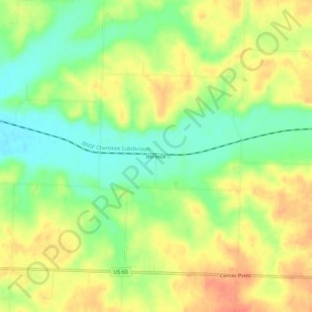
Name: Berwick topographic map, elevation, terrain.

Location: Berwick, Newton County, Missouri, United States (36.91312 -94.11466 36.95312 -94.07466)

Average elevation: 1,188 ft

Minimum elevation: 1,099 ft

Maximum elevation: 1,270 ft

Newton County trails, hiking, mountain biking, running and outdoor activities

Other topographic maps

Click on a map to view its topography, its elevation and its terrain.

Neosho

United States > Missouri > Newton County

Average elevation: 1,178 ft

Neosho

United States > Missouri > Newton County

Average elevation: 1,178 ft

Wentworth

United States > Missouri > Newton County

Average elevation: 1,237 ft

Fairview

United States > Missouri > Newton County

Average elevation: 1,283 ft

Gear up for your next adventure:

GPS Sports Watch - GPS watch for running, hiking and training
📦Gear Storage Bags - Organize and protect outdoor equipment
🕶️GPS Smartphone Mount - Secure mount for phone navigation
🧣Merino Neck Gaiters - Multi-functional headwear for wind and sun protection
🌲Outdoor Survival Books - Best books on survival skills

As an Amazon Associate, this site earns from qualifying purchases at no extra cost to you.