
Make a donation
Gear up for your next adventure:
As an Amazon Associate, this site earns from qualifying purchases at no extra cost to you.
St. John's topographic map
Click on the map to display elevation.
Make a donation
Gear up for your next adventure:
As an Amazon Associate, this site earns from qualifying purchases at no extra cost to you.
About this map
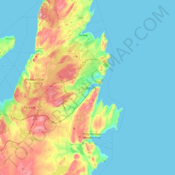
Name: St. John's topographic map, elevation, terrain.
Average elevation: 217 ft
Minimum elevation: -3 ft
Maximum elevation: 892 ft
Make a donation
Gear up for your next adventure:
As an Amazon Associate, this site earns from qualifying purchases at no extra cost to you.
Other topographic maps
Click on a map to view its topography, its elevation and its terrain.
Signal Hill National Historic Site
Canada > Newfoundland and Labrador > St. John's
Average elevation: 95 ft
Make a donation
Gear up for your next adventure:
As an Amazon Associate, this site earns from qualifying purchases at no extra cost to you.
Make a donation
Gear up for your next adventure:
As an Amazon Associate, this site earns from qualifying purchases at no extra cost to you.
Memorial University of Newfoundland main campus
Canada > Newfoundland and Labrador > St. John's
Average elevation: 256 ft