
Make a donation
Gear up for your next adventure:
As an Amazon Associate, this site earns from qualifying purchases at no extra cost to you.
Mukran topographic map
Click on the map to display elevation.
Make a donation
Gear up for your next adventure:
As an Amazon Associate, this site earns from qualifying purchases at no extra cost to you.
About this map
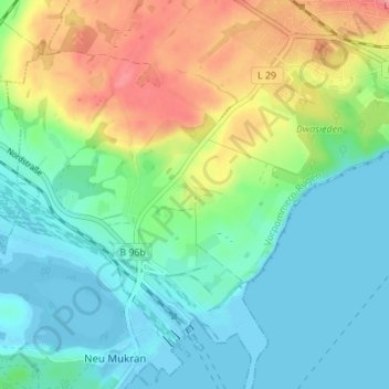
Name: Mukran topographic map, elevation, terrain.
Average elevation: 95 ft
Minimum elevation: -10 ft
Maximum elevation: 295 ft
Make a donation
Gear up for your next adventure:
As an Amazon Associate, this site earns from qualifying purchases at no extra cost to you.
Other topographic maps
Click on a map to view its topography, its elevation and its terrain.
Nationalpark Jasmund
Deutschland > Mecklenburg-Vorpommern > Vorpommern-Rügen > Sassnitz
Das Gebiet des Nationalparks Jasmund umfasst den mit ursprünglichem Buchenwald bestockten Höhenrücken der Stubnitz nördlich der Hafenstadt Sassnitz mit der Kreide-Kliffküste (2.200 ha) (charakteristisch vor allem die Stubbenkammer), einen 500 Meter weit in die Ostsee hinein reichenden Wasserstreifen (603…
Average elevation: 217 ft