
Make a donation
Gear up for your next adventure:
As an Amazon Associate, this site earns from qualifying purchases at no extra cost to you.
Nationalpark Jasmund topographic map
Click on the map to display elevation.
Make a donation
Gear up for your next adventure:
As an Amazon Associate, this site earns from qualifying purchases at no extra cost to you.
Nationalpark Jasmund
Das Gebiet des Nationalparks Jasmund umfasst den mit ursprünglichem Buchenwald bestockten Höhenrücken der Stubnitz nördlich der Hafenstadt Sassnitz mit der Kreide-Kliffküste (2.200 ha) (charakteristisch vor allem die Stubbenkammer), einen 500 Meter weit in die Ostsee hinein reichenden Wasserstreifen (603 ha) sowie 200 ha im Westen des Nationalparks, die sich aus den ehemaligen Quoltitzer Kreidebrüchen, Wiesen, Mooren und Trockenrasen zusammensetzen. Die höchste Erhebung Rügens, der 161 Meter hohe Piekberg, befindet sich ebenfalls im Nationalpark.
Make a donation
Gear up for your next adventure:
As an Amazon Associate, this site earns from qualifying purchases at no extra cost to you.
About this map
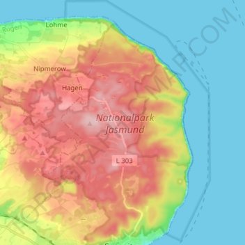
Name: Nationalpark Jasmund topographic map, elevation, terrain.
Average elevation: 217 ft
Minimum elevation: 0 ft
Maximum elevation: 538 ft
Make a donation
Gear up for your next adventure:
As an Amazon Associate, this site earns from qualifying purchases at no extra cost to you.
Other topographic maps
Click on a map to view its topography, its elevation and its terrain.
Stubbenkammer
Deutschland > Mecklenburg-Vorpommern > Vorpommern-Rügen > Sassnitz
Average elevation: 177 ft