Geolocate

Sepuka topographic map

Click on the map to display elevation.

About this map

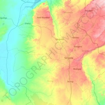
Name: Sepuka topographic map, elevation, terrain.

Location: Sepuka, Ikungi, Singida Region, Central Zone, Tanzania (-5.44920 33.83352 -4.04920 35.23352)

Average elevation: 4,400 ft

Minimum elevation: 3,402 ft

Maximum elevation: 6,772 ft

Other topographic maps

Click on a map to view its topography, its elevation and its terrain.

Manyoni

Tanzania > Singida Region

Average elevation: 3,799 ft

Igauri

Tanzania > Singida Region > Igauli

Average elevation: 5,210 ft

forest cover

Tanzania > Singida Region

Average elevation: 3,724 ft

Itigi

Tanzania > Singida Region

Average elevation: 4,045 ft

Gear up for your next adventure:

🧦Hiking Socks - Comfortable socks to prevent blisters on long hikes
🌄Hiking Binoculars - Compact binoculars for scenic views and trail spotting
🪄Magnetic Compass - Accurate compass for navigation
🛰️Handheld GPS Units - Professional satellite navigators for precise backcountry mapping
🌡️Portable Weather Meter - Track weather conditions on the trail

As an Amazon Associate, this site earns from qualifying purchases at no extra cost to you.