
Make a donation
Gear up for your next adventure:
As an Amazon Associate, this site earns from qualifying purchases at no extra cost to you.
Pushchino topographic map
Click on the map to display elevation.
Make a donation
Gear up for your next adventure:
As an Amazon Associate, this site earns from qualifying purchases at no extra cost to you.
Pushchino
Altitudes range from 104 m (beach of Oka) to 219 m on the plateau. The Oka river, one of the largest tributaries of the Volga, is a typical lowland river in the forest zone of the European part of Russia with a well-established valley. Special aspects of Oka are frequent spring and autumn floods and large fluctuations in levels. Its width at Pushchino on average is 150-200m and does not exceed 250 m, and the depth reaches 3.75 m. Average flow velocity is 0.25 m/s, mean volume 159 m³/s. Three rivers small at Pushchino make their way into the Oka: the Khokhla, the Neglyadeyka and the Lyubozhiha.
Make a donation
Gear up for your next adventure:
As an Amazon Associate, this site earns from qualifying purchases at no extra cost to you.
About this map
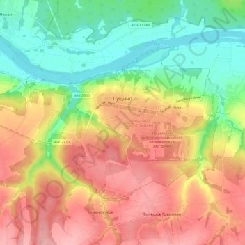
Name: Pushchino topographic map, elevation, terrain.
Average elevation: 541 ft
Minimum elevation: 338 ft
Maximum elevation: 745 ft
Make a donation
Gear up for your next adventure:
As an Amazon Associate, this site earns from qualifying purchases at no extra cost to you.
Other topographic maps
Click on a map to view its topography, its elevation and its terrain.