Geolocate

Smith Dam topographic map

Click on the map to display elevation.

About this map

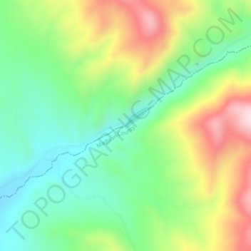
Name: Smith Dam topographic map, elevation, terrain.

Location: Smith Dam, Madison County, Montana, United States (45.65079 -112.62484 45.65089 -112.62474)

Average elevation: 5,909 ft

Minimum elevation: 5,367 ft

Maximum elevation: 6,791 ft

Other topographic maps

Click on a map to view its topography, its elevation and its terrain.

Ennis

United States > Montana > Madison County

Average elevation: 4,964 ft

Alder

United States > Montana > Madison County

Average elevation: 5,230 ft

Twin Bridges

United States > Montana > Madison County

Average elevation: 4,639 ft

Alder

United States > Montana > Madison County

Average elevation: 5,230 ft

Alder

United States > Montana > Madison County

Average elevation: 5,230 ft

Gear up for your next adventure:

🥇GPS Hiking Watch - Multi‑sport GPS watch with navigation and trail tracking
👟Men's Trail Runners - Lightweight footwear for fast-paced exploration and light hiking
📶Vehicle Signal Boosters - Improve reception in rural areas while driving to trailheads
🏥Hiking First Aid Kits - Comprehensive medical kits for remote trail injuries
🪵Folding Camp Saw - Compact saw for wood and campsite work

As an Amazon Associate, this site earns from qualifying purchases at no extra cost to you.