
Make a donation
Gear up for your next adventure:
As an Amazon Associate, this site earns from qualifying purchases at no extra cost to you.
Colbertaldo topographic map
Click on the map to display elevation.
Make a donation
Gear up for your next adventure:
As an Amazon Associate, this site earns from qualifying purchases at no extra cost to you.
About this map
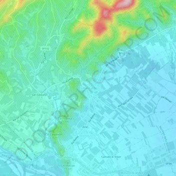
Name: Colbertaldo topographic map, elevation, terrain.
Location: Colbertaldo, Vidor, Treviso, Veneto, 31020, Italia (45.85737 12.02538 45.89737 12.06538)
Average elevation: 568 ft
Minimum elevation: 423 ft
Maximum elevation: 1,289 ft
Make a donation
Gear up for your next adventure:
As an Amazon Associate, this site earns from qualifying purchases at no extra cost to you.
Other topographic maps
Click on a map to view its topography, its elevation and its terrain.
Mogliano Veneto
Il moglianese è del tutto pianeggiante e l'altitudine passa dai 2 ai 16 m s.l.m.; la casa comunale si trova ad 8 m s.l.m. Il terreno è per lo più argilloso, il che ha permesso che le acque rimanessero in superficie creando una rete idrica piuttosto rilevante: fiume principale è lo Zero, che passa vicino al…
Average elevation: 26 ft
Montebelluna
Il territorio di Montebelluna è in gran parte pianeggiante, con altitudini che variano dai 69 m s.l.m., riscontrabili a sud di San Gaetano, ai 144 m, a nord di Pederiva. Il paesaggio si caratterizza poi per la presenza di due colline, comprendendo l'estremità occidentale del Montello (dove si ravvisa…
Average elevation: 407 ft
Make a donation
Gear up for your next adventure:
As an Amazon Associate, this site earns from qualifying purchases at no extra cost to you.
Vittorio Veneto
Oltre al centro di Vittorio Veneto, diviso tra Ceneda e Serravalle, sono presenti altri quartieri e sobborghi quali San Giacomo di Veglia, San Lorenzo, Costa e Salsa. Si contano inoltre numerose frazioni e località sparse sulle pendici dei monti o nella Val Lapisina, ossia la vallata che, inserendosi tra le…
Average elevation: 1,722 ft
Make a donation
Gear up for your next adventure:
As an Amazon Associate, this site earns from qualifying purchases at no extra cost to you.
Make a donation
Gear up for your next adventure:
As an Amazon Associate, this site earns from qualifying purchases at no extra cost to you.
Make a donation
Gear up for your next adventure:
As an Amazon Associate, this site earns from qualifying purchases at no extra cost to you.
Make a donation
Gear up for your next adventure:
As an Amazon Associate, this site earns from qualifying purchases at no extra cost to you.
Portobuffolè
Il comune si trova a 50 km dal capoluogo Treviso e a una quindicina da Pordenone. L'altitudine in corrispondenza del paese è di 10 m s.l.m. (casa comunale).
Average elevation: 36 ft
Revine Lago
La prima è costituita da un pendio molto ripido e quasi completamente ricoperto di boschi che parte dalle cime delle Prealpi Bellunesi (Monte Cor, La Posa), situate a una quota di 1200-1300 m ca., e arriva sino al fondovalle. L'altitudine massima è di 1344 m. Nella parte bassa si trovano invece i laghi di…
Average elevation: 2,247 ft
Make a donation
Gear up for your next adventure:
As an Amazon Associate, this site earns from qualifying purchases at no extra cost to you.
Cison di Valmarino
Il comune copre un'area di 28,81 km² ad un'altitudine di 261 m s.l.m.
Average elevation: 1,850 ft
San Zenone degli Ezzelini
Il territorio è pianeggiante a nord e a sud, ma al centro è attraversato da una serie di modesti rilievi, ultime propaggini dei colli Asolani. L'altitudine massima è la cima del colle San Lorenzo (245 m s.l.m.), all'estremità occidentale; seguono, procedendo verso est, il Coll'Alto (236 m) e il monte…
Average elevation: 371 ft
Make a donation
Gear up for your next adventure:
As an Amazon Associate, this site earns from qualifying purchases at no extra cost to you.
Nervesa della Battaglia
Il comune di Nervesa della Battaglia occupa un'area di 34,97 km² alle pendici più orientali del colle del Montello, a un'altitudine di 78 m s.l.m.
Average elevation: 315 ft
Make a donation
Gear up for your next adventure:
As an Amazon Associate, this site earns from qualifying purchases at no extra cost to you.
Make a donation
Gear up for your next adventure:
As an Amazon Associate, this site earns from qualifying purchases at no extra cost to you.
Breda di Piave
Il territorio di Breda di Piave è prevalentemente pianeggiante, con un'altitudine media di 23 metri sul livello del mare. Situato sulla riva destra del Piave, il comune gode della vicinanza a questo importante corso d'acqua, che ha segnato la storia e lo sviluppo del Veneto. L’area è caratterizzata da…
Average elevation: 72 ft
Make a donation
Gear up for your next adventure:
As an Amazon Associate, this site earns from qualifying purchases at no extra cost to you.
Cordignano
Situato al confine tra Veneto e Friuli-Venezia Giulia (provincia di Pordenone), il comune di Cordignano abbraccia una notevole porzione di territorio, di altitudine variabile tra i 25 e i 1079 m s.l.m., estendendosi dall'altopiano del Cansiglio alla pianura sottostante, a nord della Strada statale 13…
Average elevation: 627 ft
Vittorio Veneto
Oltre al centro di Vittorio Veneto, diviso tra Ceneda e Serravalle, sono presenti altri quartieri e sobborghi quali San Giacomo di Veglia, San Lorenzo, Costa e Salsa. Si contano inoltre numerose frazioni e località sparse sulle pendici dei monti o nella Val Lapisina, ossia la vallata che, inserendosi tra le…
Average elevation: 1,722 ft
Make a donation
Gear up for your next adventure:
As an Amazon Associate, this site earns from qualifying purchases at no extra cost to you.
Oderzo
Inserito nel cuore della pianura veneta, il territorio del comune di Oderzo è completamente pianeggiante essendo interamente compreso tra i 6 e i 15 m s.l.m. A presentare i maggiori dislivelli è la zona centrale, su cui si estende il capoluogo. Le differenze di altitudine un tempo erano più marcate, oggi…
Average elevation: 36 ft
Make a donation
Gear up for your next adventure:
As an Amazon Associate, this site earns from qualifying purchases at no extra cost to you.
Cison di Valmarino
Il comune copre un'area di 28,81 km² ad un'altitudine di 261 m s.l.m.
Average elevation: 1,850 ft
Borso del Grappa
I mieli profumati alle erbe del Grappa sono da ritenersi un importante prodotto alimentare e provengono da una grande varietà di specie botaniche che presentano una fioritura scalare tipica della zona che va da un'altitudine di 100 metri fino ai 1700 dell'alta montagna. Grazie alla possibilità di trasferire…
Average elevation: 2,093 ft
Make a donation
Gear up for your next adventure:
As an Amazon Associate, this site earns from qualifying purchases at no extra cost to you.
Make a donation
Gear up for your next adventure:
As an Amazon Associate, this site earns from qualifying purchases at no extra cost to you.
Treviso
L'altitudine minima è di 6 m s.l.m. e si riscontra all'estremità sudorientale del territorio comunale, in località Sant'Antonino; di contro, il punto di massima, 31 m s.l.m., corrisponde all'estremità nordoccidentale, nei pressi di Santa Bona. Il municipio, Ca' Sugana, si trova invece a 15 m s.l.m. Per…
Average elevation: 52 ft
Make a donation
Gear up for your next adventure:
As an Amazon Associate, this site earns from qualifying purchases at no extra cost to you.
Make a donation
Gear up for your next adventure:
As an Amazon Associate, this site earns from qualifying purchases at no extra cost to you.
Nervesa della Battaglia
Il comune di Nervesa della Battaglia occupa un'area di 34,97 km² alle pendici più orientali del colle del Montello, a un'altitudine di 78 m s.l.m.
Average elevation: 315 ft
Make a donation
Gear up for your next adventure:
As an Amazon Associate, this site earns from qualifying purchases at no extra cost to you.
Mogliano Veneto
Il moglianese è del tutto pianeggiante e l'altitudine passa dai 2 ai 16 m s.l.m.; la casa comunale si trova ad 8 m s.l.m. Il terreno è per lo più argilloso, il che ha permesso che le acque rimanessero in superficie creando una rete idrica piuttosto rilevante: fiume principale è lo Zero, che passa vicino al…
Average elevation: 26 ft
Make a donation
Gear up for your next adventure:
As an Amazon Associate, this site earns from qualifying purchases at no extra cost to you.
Pederobba
L'altitudine massima è di 780 m s.l.m. e si ravvisa in corrispondenza del Monfenera, estremità orientale del gruppo del Grappa e limite settentrionale del comune. La minima è di 134 m e corrisponde al letto del Piave presso la zona di Covolo.
Average elevation: 797 ft